Sint Geertruid
| Sint Geertruid Se-Gietere | |
|---|---|
| Village | |
| Coordinates: 50°47′47″N 5°45′56″E / 50.79639°N 5.76556°E | |
| Country | Netherlands |
| Province | Limburg (Netherlands) |
| Municipality | Eijsden-Margraten |
| Area | |
| • Total | 0.49 km2 (0.19 sq mi) |
| Population (2007) | 950 |
Sint Geertruid (Limburgish: Se-Gietere) is a village in the Dutch province of Limburg. It is located the municipality of Eijsden-Margraten.
Sint Geertruid was a separate municipality until 1982, when it was merged with Margraten. The municipality was formed in 1828 from parts of the municipalities of Breust and Eijsden.[1]
Part of the Sint Geertruid population centre in the Eijsden-Margraten municipality are also the separately situated townships of: Bruisterbosch (80 inhabitants), Herkenrade (180), Libeek (65) and Moerslag (55).
A significant part of the "Savelsbos" hill side forest[2] is situated in the outlying area of Sint Geertruid.
.JPG) Half timbered house at Libeek |
.JPG) Sint Geertruid-Heerkuil |
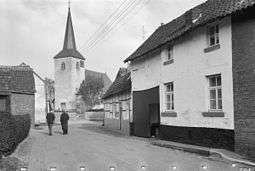 Village view back in 1962 |
References
- ↑ Ad van der Meer and Onno Boonstra, Repertorium van Nederlandse gemeenten, KNAW, 2006.
- ↑ NlWp article Savelsbos
External links
| Wikimedia Commons has media related to Sint Geertruid. |
- J. Kuyper, Gemeente Atlas van Nederland, 1865-1870, "Sint Geertruid". Map of the former municipality, around 1868.
Coordinates: 50°48′N 5°46′E / 50.800°N 5.767°E
| Authority control |
|---|
This article is issued from
Wikipedia.
The text is licensed under Creative Commons - Attribution - Sharealike.
Additional terms may apply for the media files.