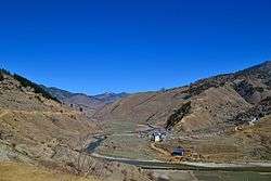
Sinja Valley
| Sinja सिञ्जा उपत्यका | |
|---|---|
| Valley | |
 Narakot Sinja Valley | |
 Sinja Location in Nepal | |
| Coordinates: 29°19′28″N 81°58′57″E / 29.32444°N 81.98250°ECoordinates: 29°19′28″N 81°58′57″E / 29.32444°N 81.98250°E | |
| Country |
|
| Province | Karnali Provinces |
| District | Jumla District |
| Time zone | UTC+5:45 (Nepal Time) |
The Sinja Valley is located in the Jumla District in Karnali Province, of Nepal.
Site description
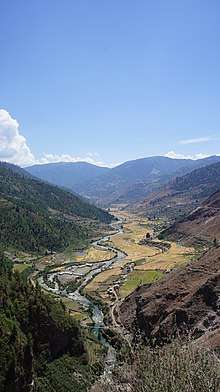
The valley houses the ancient capital city of the Khasas that ruled this area from the 12th to the 14th Century. Palaces, temples, and the ancient remains of a settlement were uncovered during excavations spearheaded by the Department of Archaeology at Cambridge University. Major finds from the site include a large network of underground pipes that formed a complex water delivery system as well as a ring of massive monolithic stone columns circumscribing the settlement.[1]
On the cliffs at the valley edge were found some of the earliest written examples of Nepali language.
History
The Khasa kingdom fragmented into twenty-two individual kingdoms after the 14th century, which then remained until Nepal was unified in the 18th century.[1] The founder of Sinja valley was Nagraj.
World Heritage Status
This site was added to the UNESCO World Heritage Tentative List on January 30, 2008 in the Cultural category.[1]
Notes
References
Sinja valley - UNESCO World Heritage Centre Retrieved 2009-03-03.