Sindh Sagar Doab
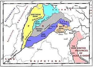
The Sindh Sagar Doab (Urdu: سندھ ساگر دوآب) is the tract of land in Pakistan lying between the Indus River and the Jhelum River[1] It is one of the five major doabs of the Punjab and forms the north western portion of the Punjab plain.
Major areas in this doab include the Kala Chitta Range, Margalla and Murti Hills, Potohar Plateau, Salt Range and the Thal Desert. Some of the major cities of this doab are , Rawalpindi, Taxila, Attock, Chakwal, Jhelum, Pind Dadan Khan, Talagang, Mianwali, Bhakkar, Leiah (Layya), Muzaffargarh, Khushab and Quaidabad.
The word doab is of Persian origin, signifying the region between two rivers.[2] According to Shaikh Abu'l-Fazl ibn Mubarak, the grand vizier of the Mughal emperor Akbar, and author of the Akbarnama, the names of the doabs were decided by Akbar.[3]
Of the Punjab doabs, the Sindh Sagar Doab is the largest in land area, but the poorest for agriculture,[2] due to the presence of the Salt Range and the Thal desert. The Potohar plateau is the location of Pakistan's major oil fields, at Khaur, Dhuliān and Tut. A pipeline connects the oil fields to the refinery at Rāwalpindi.[4]
References
- ↑ Penn, James R (2001). Rivers of the World. p. 122. ISBN 1-57607-042-5.
- 1 2 Zubair Shafi Ghauri; Noah Tesch (2010). "Sindh Sagar Doab". Encyclopædia Britannica. Retrieved 9 August 2017.
- ↑ (Abul Fazl, Aaeen-i-Akbari, Fida Ali (tr.), Lahore, Sang-e-Meel Publications, PP: 1019)
- ↑ "Potohar Plateau". Pakistan Tourism Development Corporation. Retrieved 9 August 2017.