Simpson River
| Simpson River | |
|---|---|
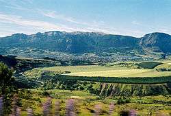 Coihaique in the distance. | |
| Country | Chile |
| Physical characteristics | |
| River mouth | Aisén River |
| Length | 88 km (55 mi)[1] |
| Discharge |
|
| Basin features | |
| Basin size | 3,712 km2 (1,433 sq mi)[1] |
Simpson River is a river of Chile located in the Aysén del General Carlos Ibáñez del Campo Region. The river originates east of the Andes mountains. It forms the western boundary of the city of Coihaique, which is bordered on the north by the Coihaique River, a tributary of the Simpson. In its inferior course, the river flows through Río Simpson National Reserve, which is named after the river. In this area, the river roughly parallels the Route CH-240, which connects Coihaique with Puerto Aisén and Puerto Chacabuco.
Tributaries
The Blanco River gushes through canyons in the northeastern part of Reserva Nacional Cerro Castillo. The river corridor is a veritable geological wonder with a myriad of canyons composed of dark basalt, limestone, shale and sandstone. There is also the wonderful sight of Cerro Castillo (2675 m), highest peak in the region, thus named because it resembles a medieval castle.[2]
References
- 1 2 3 "Principales ríos, embalses, lagos y lagunas de Chile". Panorama Económico Social: las regiones de Chile 1990 - 2005. MIDEPLAN, INE. Archived from the original on 2008-03-18. Retrieved 2008-03-16.
- ↑ "Río Blanco (Cerro Castillo)". Retrieved 13 February 2013.
| Rivers | .png) | |
|---|---|---|
| Lakes | ||
| Glaciers | ||