Chacabuco River
| Chacabuco River | |
|---|---|
 | |
|
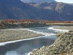
Chacabuco River in the Aysén Region | |
| Country | Chile |
| Physical characteristics | |
| River mouth | Baker River |
| Length | 76 km (47 mi)[1] |
The Chacabuco River is a river of Chile located in the Aysén del General Carlos Ibáñez del Campo Region. The river rises in a col between Cerro Lucas Bridges and Cerro Baker.[1] The latter is a mountain on the Argentina-Chile border, close to Roballos Pass.
Patagonia Park occupies the most of Chacabuco River Basin. There is a project to create a national park, which will comprise the lands of Patagonia Park, Lago Cochrane National Reserve and Lago Jeinimeni National Reserve.
See also
References
- 1 2 Niemeyer, Hans (1980). "Hoyas hidrográficas de Chile. Duodécima Región". Ministerio de Obras Públicas. Dirección General de Aguas. Retrieved 2012-03-17.
| Rivers | .png) | |
|---|---|---|
| Lakes | ||
| Glaciers | ||
This article is issued from
Wikipedia.
The text is licensed under Creative Commons - Attribution - Sharealike.
Additional terms may apply for the media files.