Simpson, Minnesota
| Simpson, Minnesota | |
|---|---|
| Unincorporated community | |
 Simpson, Minnesota Location of the community of Simpson within Pleasant Grove Township, Olmsted County  Simpson, Minnesota Simpson, Minnesota (the US) | |
| Coordinates: 43°55′26″N 92°24′36″W / 43.92389°N 92.41000°WCoordinates: 43°55′26″N 92°24′36″W / 43.92389°N 92.41000°W | |
| Country | United States |
| State | Minnesota |
| County | Olmsted |
| Township | Pleasant Grove Township |
| Elevation | 1,270 ft (390 m) |
| Time zone | UTC-6 (Central (CST)) |
| • Summer (DST) | UTC-5 (CDT) |
| ZIP code | 55904 |
| Area code(s) | 507 |
| GNIS feature ID | 652079[1] |
Simpson is an unincorporated community in Pleasant Grove Township, Olmsted County, Minnesota, United States, near Rochester and Stewartville. The community is located along Olmsted County Road 1 (Simpson Road) near County Road 16 and 68th Street SE. Whitney Creek flows nearby.
History
Simpson was platted in 1890, and named for Thomas Simpson, a railroad official.[2] A post office was established at Simpson in 1890, and remained in operation until 1956.[3]
References
- ↑ "Simpson, Minnesota". Geographic Names Information System. United States Geological Survey.
- ↑ Upham, Warren (1920). Minnesota Geographic Names: Their Origin and Historic Significance. Minnesota Historical Society. p. 388.
- ↑ "Olmsted County". Jim Forte Postal History. Retrieved 27 July 2015.
Municipalities and communities of Olmsted County, Minnesota, United States | ||
|---|---|---|
| Cities | 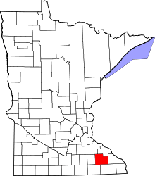 | |
| Townships | ||
| Unincorporated communities | ||
| Footnotes | ‡This populated place also has portions in an adjacent county or counties | |
This article is issued from
Wikipedia.
The text is licensed under Creative Commons - Attribution - Sharealike.
Additional terms may apply for the media files.