Simmondley
| Simmondley | |
|---|---|
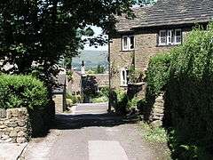 Simmondley Village off Old Lane | |
 Simmondley Simmondley shown within Derbyshire | |
| Population | 4,727 (Including Charlestown. Ward. 2011) |
| OS grid reference | SK018931 |
| District | |
| Shire county | |
| Region | |
| Country | England |
| Sovereign state | United Kingdom |
| Post town | GLOSSOP |
| Postcode district | SK13 |
| Police | Derbyshire |
| Fire | Derbyshire |
| Ambulance | North West |
| EU Parliament | East Midlands |
Simmondley is a small village near the town of Glossop in Derbyshire, England. The population of the High Peak ward at the 2011 Census was 4,727.[1] It has one pub, the Hare and Hounds, in the south of the village at the top of Simmondley Lane. The pub is a part of the original farming community with the adjacent farmhouse, barn and stables converted into houses. The Jubilee pub was built in 1977, in celebration of the Silver Jubilee of Elizabeth II. After 40 years, the brewery that owned the Jubilee sold it at auction; the buyer demolished the building in 2017 to build houses on the site and adjoining car park.
In August 1981 the Sorgro convenience store opened on Pennine Road. In recent years this has been a Spar, an Alldays and is currently The Co-operative Food. There is a post office, a Chinese takeaway, a dentist, a doctor, a chemist, two hairdressers, a pre-school and a primary school with over 300 pupils.[2]
Many large housing projects have recently been completed in Simmondley, including a large housing estate off Valley Road that stretches towards the existing Manchester rail line.
Simmondley has a number of public areas including: a children's play park area with swings and a centre climbing frame; an enclosed games court called the S.M.U.G.A (Simmondley Multi Use Games Area) with football nets and basketball hoops with flood lighting; open grassland around the estate mainly surrounding the Werneth Road area; a village green to the top of Simmondley with a public phone box, post box, plant pots and seating (during the Christmas period this is the location of the Simmondley Christmas Tree).
The housing developments south of the village have led to it being considered by some as a suburb of Glossop, rather than a separate settlement as it is contiguous with Glossop, although in recent years the local council has installed Simmondley signs at accesses to the village to mark that it has its own separate identity.
Simmondley is at the bottom of the so-called Monks' Road, a road used by the monks of Basingwerk Abbey to administer the abbey's estate. It leads to Charlesworth, Chisworth and Hayfield.
References
- ↑ "High Peak ward population 2011". Neighbourhood Statistics. Office foer National Statistics. Retrieved 22 March 2016.
- ↑ Ofsted Archived 2006-01-07 at the Wayback Machine. accessed 4 May 2008
External links
![]()