Semien Mountains
.jpg)
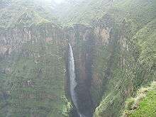
The Semien Mountains (Amharic: ስሜን ተራሮች) (or Səmen; also spelled Simien and Simen), in northern Ethiopia, north east of Gondar in Amhara region, are part of the Ethiopian Highlands. They are a World Heritage Site and include the Simien Mountains National Park. The mountains consist of plateaus separated by valleys and rising to pinnacles. The tallest peak is Ras Dejen (4,550 m); other notable heights include Mounts Biuat (4,437 m) and Kidis Yared (4,453 m).
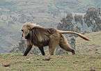
Because of their geological origins, the mountains are almost unique, with only South Africa's Drakensberg having been formed in the same manner and thus appearing similar. Notable animals in the mountains include the walia ibex, gelada, and caracal. There are a few Ethiopian wolves.
Geology and landscape
The Semien Mountains were formed prior to the creation of the Rift Valley, from lava outpourings between 40 and 25 million years ago during the Oligocene period. The volcano is believed to have spread over more than 5000 m2 and resulted in a thick sequence of basaltic lava some 3,000-3,500 m thick that was deposited on Precambrian crystalline basement. The major part of the Semien Mountains consists of remnants of a Hawaiian-type shield volcano. The Kidus Yared peak is situated near the center of the shield volcano. Ras Dejen (4,533 m), Bwahit (4,430 m) and Silki (4,420 m) were formed from the outer core of this ancient volcano.
The extreme escarpment in Semien appears to be a precondition for the formation of the extended uplift of the whole mountain massif 75 million years ago. The dramatic views are due to this volcanic activity. Especially of note is the 2,000 m high escarpment extending in a southwest-northeast direction.
There are different types of soils as a result of the difference in geological formation, glaciations, topography, and climate. The Humic Andosol is the dominant soil type which is mainly found at an altitude of 3,000 m. The other types of soil are shallow Andosols, Lithosols, and Haplic Phaeozems that are mainly common in the area between 2,500 and 3,500 m. The Semien Mountains are highly eroded as a result of human land use practices and as a result of the topography of the area.
Human history
Although the word Semien means "north" in Amharic, according to Richard Pankhurst the ancestral form of the word actually meant "south" in Ge'ez, because the mountains lay to the south of Aksum, which was at the time the center of Ethiopian civilization. But as over the following centuries the center of Ethiopian civilization itself moved to the south, these mountains came to be thought of as lying to the north, and the meaning of the word likewise changed.[1]
The Semiens are remarkable as being one of the few spots in Africa where snow regularly falls.[2] First mentioned in the Monumentum Adulitanum of the 4th century AD (which described them as "inaccessible mountains covered with snow" and where soldiers walked up to their knees in snow), the presence of snow was undeniably witnessed by the 17th century Jesuit priest Jerónimo Lobo.[3] Although the later traveler James Bruce claims that he had never witnessed snow in the Semien Mountains, the 19th century explorer Henry Salt not only recorded that he saw snow there (on 9 April 1814), but explained the reason for Bruce's failure to see snow in these mountains – Bruce had ventured no further than the foothills into the Semiens.[4]
Despite their ruggedness and altitude, the mountains are dotted with villages linked by tracks. Historically they were inhabited by Ethiopian Jews (the Beta Israel), who after repeated attacks by the zealous Christian Emperors in the 15th century withdrew from the province of Dembiya into the more defensible Semien mountains.[5]
Towards the end of the Zemene Mesafint, Dejazmach Wube Haile Mariam maintained his arsenal and treasury on Mount Hai.[6]
Gallery
References
- ↑ "Historical Notes on Books: An Early Ethiopian Map" (Capital newspaper website)
- ↑ Discussed further in Frederick J. Simoons, "Snow in Ethiopia: A Review of the Evidence", Geographical Review, 50 (1960), pp. 402-411.
- ↑ Donald M. Lockhart (translator), The Itinerário of Jerónimo Lobo (London: Hakluyt Society, 1984), p. 240.
- ↑ Henry Salt, A Voyage to Abyssinia and Travels into the Interior of that Country, 1814 (London: Frank Cass, 1967), p. 352.
- ↑ One account of this process is James Quirin, "Caste and Class in Historical North-West Ethiopia: The Beta Israel (Falasha) and Kemant, 1300-1900", Journal of African History, 39 (1998), pp. 195-220
- ↑ Henry A. Stern, Wanderings among the Falashas in Abyssinia (London, 1862), p. 75
Coordinates: 13°29′34″N 38°26′37″E / 13.49278°N 38.44361°E