Sigglesthorne
| Sigglesthorne | |
|---|---|
 Sigglesthorne Sigglesthorne shown within the East Riding of Yorkshire | |
| Population | 404 (2011 census)[1] |
| OS grid reference | TA155457 |
| Civil parish |
|
| Unitary authority | |
| Ceremonial county | |
| Region | |
| Country | England |
| Sovereign state | United Kingdom |
| Post town | HULL |
| Postcode district | HU11 |
| Dialling code | 01964 |
| Police | Humberside |
| Fire | Humberside |
| Ambulance | Yorkshire |
| EU Parliament | Yorkshire and the Humber |
| UK Parliament | |
Sigglesthorne is a small village and civil parish in the East Riding of Yorkshire, England. It is situated approximately 3 miles (4.8 km) west of Hornsea on the A1035 road (formerly B1244) where it meets the B1243 road.
According to the 2011 UK census, Sigglesthorne parish had a population of 404,[1] an increase on the 2001 UK census figure of 282.[2]
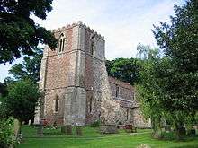
The village has around 175 houses. There is also an ancient church dedicated to St. Lawrence that was designated a Grade II* listed building in 1966 and is now recorded in the National Heritage List for England, maintained by Historic England.[3] There is also a Church of England school.
It is rumoured throughout the village that the settlement was given its name as a result of a Viking who lived there. This Viking leader was supposedly called Siggle/Siggul, and since hawthorne is the predominant type of hedge around the village, it was given the name "Siggul's thorne" → Sigglesthorne.
Hornsea Road in Sigglesthorne is now the home to a large garden centre named Spring Garden Centre.
References
- 1 2 UK Census (2011). "Local Area Report – Sigglesthorne Parish (1170211255)". Nomis. Office for National Statistics. Retrieved 24 February 2018.
- ↑ "2001 Census: Key Statistics: Parish Headcounts: Area: Sigglesthorne CP (Parish)". Neighbourhood Statistics. Office for National Statistics. Retrieved 20 May 2008.
- ↑ Historic England. "Church of St Lawrence (1249769)". National Heritage List for England. Retrieved 16 August 2013.
- Gazetteer — A–Z of Towns Villages and Hamlets. East Riding of Yorkshire Council. 2006. p. 10.
External links
| Wikimedia Commons has media related to Sigglesthorne. |
- Sigglesthorne in the Domesday Book