Sibyl Marston (ship)
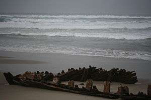 Sibyl Marston as of 24 February 2010. | |
| History | |
|---|---|
| Owner: | Sibyl Marston Co. |
| Builder: | W.A. Boole & Sons |
| Fate: | Sank 12 January 1909 |
| General characteristics | |
| Tonnage: | 1,020 GT (est.) |
| Length: | 215 ft (66 m) |
| Installed power: | Triple expansion steam |
Sibyl Marston was a wooden schooner cargo ship built by W.A. Boole & Sons of Oakland, California and belonging to the Sibyl Marston Co.[1] Sibyl Marston sank off of the coast of Lompoc, California on 12 January 1909.
Overview
On 12 January 1909, Sybil Marston, the largest steam schooner built on the United States West Coast, struck the rocks near Surf Beach, California and ran aground in a storm. She was carrying 1,100,000 board feet (3,000 m3) of lumber. Two crew members were killed in the disaster.[2]
Shortly after the Sybil Marston disaster, Lompoc residents salvaged the lumber and used it to begin a town lumberyard. Several houses built in Lompoc used lumber from the shipwreck.[3]
Surf Beach and its adjoining coastal area was a dangerous place for ship travel in the time before radar navigational systems made seafaring safer. There are about 30 recorded shipwrecks along the Surf Beach coast.
Location
The shipwreck is located 1 mile (2 km) south of the Surf Amtrak Station in Lompoc.
Sources
- "19th Century Shipbuilders on the Pacific Coast". Shipbuilding History. Retrieved 15 February 2010.
References
- ↑ "Merchant Work in Coast Yards". Marine review. Penton Publishing Company. 35 (1): 44. 3 January 1907.
- ↑ Ruhge, Justin M. (2000). Maritime Tragedies on the Santa Barbara Channel. Quantum Imaging Associates.
- ↑ Nisperos, Neil (29 January 2010). "Merchant steamer ship visible at Surf Beach". Lompoc Record.
External links
- "Photograph of Sibyl Marston under construction". Printroom. Archived from the original on 15 July 2011.
- "Steamer driven ashore". Ogden Standard. 13 January 1909.
- McReynolds, John (2 July 2006). "Inheriting a piece of history". Lompoc Record.
- YouTube video with details of construction, 8 min.
- "Shipping Intelligence: Sailed". The San Francisco Call. 21 October 1908. p. 15.
Coordinates: 34°39′13″N 120°37′03″W / 34.653474°N 120.61747°W
| Shipwrecks |
|
|---|---|
| Other incidents |
|
1908 | |