Robert Sibley Volcanic Regional Preserve
| Robert Sibley Volcanic Regional Preserve | |
|---|---|
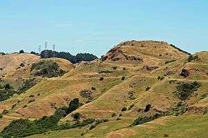 Round Top, an extinct volcano at Sibley Volcanic Regional Preserve | |
| Location | Alameda & Contra Costa Counties, California |
| Nearest city | Oakland, California |
| Coordinates | Coordinates: 37°51′18″N 122°12′12″W / 37.85495°N 122.20326°W |
| Area | 928 acres (3.76 km2) |
| Created | 1936 |
| Operated by | East Bay Regional Parks District |
Robert Sibley Volcanic Regional Preserve is located in the Berkeley Hills of the East Bay region of the San Francisco Bay Area, California.[1] The park is part of the East Bay Regional Parks District (EBRPD), covers 928 acres (3.76 km2), and lies partly in Alameda County and partly in Contra Costa County, east of Oakland. It can be entered from Oakland on Skyline Boulevard, or from Contra Costa County on Old Tunnel Road.[1]
History
The park was one of the first three parks established by the East Bay Regional Parks District (EBRPD) in 1936.[lower-alpha 1] It was originally named Round Top Regional Park. Round Top (elevation 1,761 feet/537m) is an extinct volcano in the Berkeley Hills. It is home to at least two stone labyrinths of recent origin. The park was renamed after the second president of the EBRPD, Robert Sibley, shortly after his death.[1]
Geology
The preserve contains a Pliocene epoch volcanic center that, about 10 million years ago, produced most of the lavas that underlie the East Bay ridges from Inspiration Point in Tilden Regional Park to Moraga. Geologists refer to this local volcanism as the Moraga Volcanics.[2][3][4] Subsequent compressive strains produced by various local faults including the Hayward Fault folded the lava-bearing rock formations, tilting the Round Top vent complex on its side.
Folding, erosion, and a quarry operation exposed a cross section of the great volcano, providing an excellent means to study a California Coast Ranges volcano. Lava within the vent has been dated by UC Berkeley at 9.5 million years old.[5]
Activities
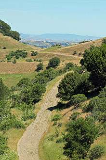
There are several trails in the preserve, with most restricted for hiking and horseback use. Only a few are available for multi-purpose use. Round Top Road is paved from the Visitor Center to the top of Round Top.[1] There are no campgrounds or picnic areas in the Preserve. The Visitor Center at the Skyline Boulevard entrance is unstaffed, but has displays depicting the areas geology. It also offers brochures to assist visitors making self-guided tours.[1]
Hiking trails
- East Bay Skyline Regional Trail, which is 31 miles (50 km) long, traverses the Sibley preserve on the ridgeline that separates between Wildcat Canyon Park and Anthony Chabot Parks.
- Round Top Road goes from the Sibley visitor center to the top of Round Top. Round Top Loop Trail circles Round Top peak.
- Volcanic Trail, once a quarry haul road, contains most of the stops on the self-guided volcanic tour.
- Quarry Trail connects the middle of Volcanic Trail to a point lower down on Quarry Road.
- Pond Trail is a short trail segment that descends to a couple of ponds on the north side of the preserve.[1]
Labyrinths
At least two man-made labyrinths exist within RSVRP. The first and, arguably most frequently visited, is known as the Mazzariello Labyrinth. Constructed in 1990 and donated as a "gift to the world," by East Bay resident Helena Mazzariello,[lower-alpha 2] It is a favorite destination for hikers who come to pray, meditate and examine talismans left in the center by previous visitors.[7] Notwithstanding the official gate hours listed below, Friends of the Labyrinth claims that the labyrinth has visitors 24 hours a day, 7 days a week.[6]
The next marker along the Round Top Loop Trail leads to the Volcanic Trail, which crosses to the left. At Post No. 4, the hiker can see a smaller, heart-shaped labyrinth. It is not nearly as elaborate as the Mazzariello Labyrinth, and apparently not as heavily used.[7]
There have been claims of other, earlier labyrinths hidden in the preserves, but Friends of the Labyrinth dismisses these as urban legends, as no evidence has been found. The organization reports that analysis of high-resolution aerial photographs show no trace of such activity.[6]
Visiting the park
The park is open year round, park and gate hours are:
- November - February 7AM - 6PM
- March - October 7AM - 10PM
There is no parking fee and no dog fee.
Notes
See also
- Moraga Formation — Pliocene epoch basaltic lava formation in park.
- Pliocene California geology
- Volcanism of California
References
- 1 2 3 4 5 6 7 ebparks.org: Robert Sibley Volcanic Regional Preserve
- ↑ USGS.gov: "Upper Cretaceous and Lower Tertiary Rocks Berkeley and San Leandro Hills, California", by J. E. Case, GEOLOGICAL SURVEY BULLETIN 1251-J, 1968.
- ↑ Oakland Geology Blog: "Grizzly Peak and Moraga basalt"
- ↑ Geology.about.com: "California Transect - Stop 30, Orinda Formation and Moraga Volcanics"
- ↑ Lawrence Berkeley Lab.gov: "Berkeley Lab Geologist Studies the Ground Beneath His Feet"
- 1 2 3 "Mazzariello's Maze." Friends of the Labyrinth. Undated Accessed July 13, 2018
- 1 2 Jones, Nicole. "Sibley Regional Preserve: A walk on Oakland’s wild and volcanic side." Oakland North. July 22, 2011. Accessed July 13, 2018.
External links
| Wikimedia Commons has media related to Robert Sibley Volcanic Regional Preserve. |