Shotwell, North Carolina
| Shotwell, North Carolina | |
|---|---|
| Unincorporated community | |
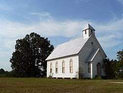 Historic Oaky Grove Methodist Church in Shotwell, North Carolina | |
 Location of Shotwell in North Carolina  Shotwell, North Carolina (the US) | |
| Coordinates: 35°44′14″N 78°26′41″W / 35.73722°N 78.44472°WCoordinates: 35°44′14″N 78°26′41″W / 35.73722°N 78.44472°W | |
| Country | United States |
| State | North Carolina |
| County | Wake |
| Elevation[1] | 289 ft (88 m) |
| Time zone | UTC-5 (Eastern (EST)) |
| • Summer (DST) | UTC-4 (EDT) |
| Area code(s) | 919 |
| FIPS code | 61740 |
| GNIS feature ID | 1006371[1] |
Shotwell is an unincorporated community in rural eastern Wake County, North Carolina, United States, located about 4 miles (6.4 km) south of Knightdale and 11 miles (18 km) east of Raleigh at the confluence of Smithfield, Mial Plantation, Major Slade, Grasshopper, and Turnipseed Roads. Shotwell has been inhabited since the early 19th century and is home to a number of historic structures. A post office was established in 1883 but closed less than two decades later.[2]
Oaky Grove was listed on the National Register of Historic Places in 1993.[3]
See also
References
- 1 2 U.S. Geological Survey Geographic Names Information System: Shotwell, North Carolina. Retrieved on 2008-04-05.
- ↑ Lewis, JD. "All Known NC Post Offices 1785 to 1971, Alphabetical Order M-Z". Retrieved 4 April 2013.
- ↑ National Park Service (2010-07-09). "National Register Information System". National Register of Historic Places. National Park Service.
Municipalities and communities of Wake County, North Carolina, United States | ||
|---|---|---|
| Cities | 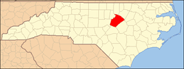 | |
| Towns | ||
| Townships | ||
| Unincorporated communities |
| |
| Footnotes | ‡This populated place also has portions in an adjacent county or counties | |
This article is issued from
Wikipedia.
The text is licensed under Creative Commons - Attribution - Sharealike.
Additional terms may apply for the media files.