Short Gap, West Virginia
| Short Gap | |
|---|---|
| Unincorporated community | |
 Short Gap Location within the state of West Virginia  Short Gap Short Gap (the US) | |
| Coordinates: 39°32′37″N 78°48′40″W / 39.54361°N 78.81111°WCoordinates: 39°32′37″N 78°48′40″W / 39.54361°N 78.81111°W | |
| Country | United States |
| State | West Virginia |
| County | Mineral |
| Time zone | UTC-5 (Eastern (EST)) |
| • Summer (DST) | UTC-4 (EDT) |
| ZIP codes | 26753, 26726 |
| GNIS feature ID | 1546727[1] |
Short Gap is an unincorporated community in Mineral County, West Virginia located at the intersection of Routes 956 and 28; about 8 miles from Cumberland, MD. The community is home to Frankfort High School, as well as Frankfort Middle School, which serve the northern part of Mineral County, including students from the towns of Ridgeley and Fort Ashby. The ZIP codes for Short Gap are 26753 (Ridgeley, WV) and 26726 (Keyser, WV).
Located in Short Gap on Knobley Road is Stewart's Tavern, listed on the National Register of Historic Places in 2000.[2]
Notable residents
- Dave Roberts (1944–2009), Major League Baseball pitcher
References
- ↑ "Short Gap". Geographic Names Information System. United States Geological Survey.
- ↑ National Park Service (2010-07-09). "National Register Information System". National Register of Historic Places. National Park Service.
Municipalities and communities of Mineral County, West Virginia, United States | ||
|---|---|---|
| City | 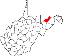 | |
| Towns | ||
| CDPs | ||
| Other localities |
| |
| Ghost towns | ||
| Footnotes | ‡This populated place also has portions in an adjacent county or counties | |
This article is issued from
Wikipedia.
The text is licensed under Creative Commons - Attribution - Sharealike.
Additional terms may apply for the media files.