Short Creek Township, Harrison County, Ohio
| Short Creek Township, Harrison County, Ohio | |
|---|---|
| Township | |
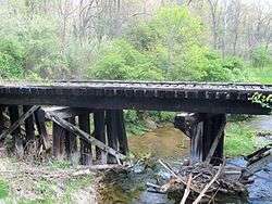 This old bridge across South Branch Short Creek next to U.S. Route 250 led to the Georgetown Mine. | |
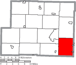 Location of Short Creek Township in Harrison County | |
| Coordinates: 40°12′33″N 80°54′38″W / 40.20917°N 80.91056°WCoordinates: 40°12′33″N 80°54′38″W / 40.20917°N 80.91056°W | |
| Country | United States |
| State | Ohio |
| County | Harrison |
| Area | |
| • Total | 30.6 sq mi (79.3 km2) |
| • Land | 30.1 sq mi (78.0 km2) |
| • Water | 0.5 sq mi (1.3 km2) |
| Elevation[1] | 945 ft (288 m) |
| Population (2010) | |
| • Total | 1,090 |
| • Density | 36/sq mi (14.0/km2) |
| Time zone | UTC-5 (Eastern (EST)) |
| • Summer (DST) | UTC-4 (EDT) |
| ZIP code | 43907 |
| Area code(s) | 740 |
| FIPS code | 39-72361[2] |
| GNIS feature ID | 1086283[1] |
Short Creek Township is one of the fifteen townships of Harrison County, Ohio, United States. As of the 2010 census the population was 1,090,[3] of whom 732 lived in the unincorporated portion of the township.[4]
Geography
Located in the southeastern corner of the county, it borders the following townships:
- Green Township - north
- Smithfield Township, Jefferson County - northeast
- Mount Pleasant Township, Jefferson County - east
- Colerain Township, Belmont County - southeast corner
- Wheeling Township, Belmont County - south
- Athens Township - southwest
- Cadiz Township - northwest
Two incorporated villages are located in Short Creek Township: Adena in the northeast, and Harrisville in the southeast.
Name and history
It is the only Short Creek Township statewide.[5]
Government
The township is governed by a three-member board of trustees, who are elected in November of odd-numbered years to a four-year term beginning on the following January 1. Two are elected in the year after the presidential election and one is elected in the year before it. There is also an elected township fiscal officer,[6] who serves a four-year term beginning on April 1 of the year after the election, which is held in November of the year before the presidential election. Vacancies in the fiscal officership or on the board of trustees are filled by the remaining trustees.
References
- 1 2 "US Board on Geographic Names". United States Geological Survey. 2007-10-25. Retrieved 2008-01-31.
- ↑ "American FactFinder". United States Census Bureau. Retrieved 2008-01-31.
- ↑ "Geographic Identifiers: 2010 Census Summary File 1 (G001): Short Creek township, Harrison County, Ohio". American Factfinder. U.S. Census Bureau. Retrieved December 29, 2017.
- ↑ "Geographic Identifiers: 2010 Census Summary File 1 (G001): Remainder of Short Creek township, Short Creek township, Harrison County, Ohio". American Factfinder. U.S. Census Bureau. Retrieved December 29, 2017.
- ↑ "Detailed map of Ohio" (PDF). United States Census Bureau. 2000. Retrieved 2007-02-16.
- ↑ §503.24, §505.01, and §507.01 of the Ohio Revised Code. Accessed 4/30/2009.
External links
Municipalities and communities of Harrison County, Ohio, United States | ||
|---|---|---|
| Villages |  | |
| Townships | ||
| CDP | ||
| Unincorporated communities | ||
| Ghost towns | ||
| Footnotes | ‡This populated place also has portions in an adjacent county or counties | |