Shoeburyness Boom

The Shoeburyness Boom (also known as the Sheerness Boom, Thames Boom or Thames Estuary Boom) refers to two defensive barriers erected across the Thames Estuary in the mid-20th century. The first example was built in 1939 during the Second World War to protect shipping from attack by submarines, mines and surface vessels, with the second being built between 1950 and 1953 to prevent access to the estuary by Soviet submarines during the Cold War.
Both booms ran from Shoeburyness in Essex to Sheerness in Kent, a distance of 5.6 miles (9.0 km). The first boom consisted of wooden piles driven into the estuary bed at either end with the deep water channel protected by an anti-submarine net. The second boom was formed of concrete piles at either end with the gap in the channel to be closed by moored Royal Navy vessels.
The development of nuclear missiles, jet bombers and the hydrogen bomb quickly rendered the Cold War boom obsolete and it was partially demolished in the 1960s. A 2 km (2200 yard) stretch of the later boom remains at the Essex side. It has been designated a scheduled monument and forms the boundary of the restricted area of the MoD Shoeburyness firing range.
Second World War boom

The boom was erected in 1939, at the start of the Second World War.[1] The primary intention was to prevent any incursion of enemy submarines up the estuary where they might be able to attack merchant shipping. Secondary benefits included protection against floating mines, enemy surface vessels and as an anti-invasion measure.[1][2]
The boom ran from the East Beach at Shoeburyness, Essex to Royal Oak Point in Sheerness, Kent a distance of some 5.6 miles (9.0 km).[3][1] In the shallow water at either end, closest to the land, the boom was formed of wooden piles driven into the sandy seabed and reinforced with concrete – on the Essex side of the boom these extended over 1 mile (1.6 km) into the estuary.[1][4]
Where the boom met the deep water channel it transitioned into an anti-submarine net.[1] At intervals along the net 200-ton lighters were stationed armed with anti-aircraft guns and searchlights.[1] Two gates were included within the net to allow for access by shipping, one towards the north for access to the Thames and one towards the south for the River Medway ports.[5] These were opened by a Royal Navy boom defence vessel and closed overnight.[1]
The boom was backed up by the nearby Maunsell Sea Forts and by a coastal battery at Shoeburyness.[3][6] The latter housed two 6" naval guns and search-light emplacements protected by landward defences.[6][7] A second boom was placed across the Thames at Canvey Island and similar protections were installed at the Solent (to protect the naval port of Southampton) and at Plymouth.[8]
The remains of the coastal artillery emplacement at Shoeburyness, together with its magazines and search-light emplacements are also visible but lie within the grounds of MoD Shoeburyness with no public access.[7] There are no visible remains of the boom at the Shoebury end but a line of piles and wrecked boats is visible on the Kent side at East End, close to Minster Beach.[9]
Gallery
 Remains of piles and wrecked boats at Royal Oak Point, East End.
 One of the gates in the boom
 Boom defence vessels
 Royal Navy diver preparing to check the mooring lines of one of the gate ships
Cold War boom
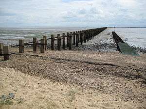
A replacement boom was constructed some 15–60 m (16–65 yards) west of the Second World War boom between 1950 and 1953 by the Admiralty. The boom comprised two off-set rows of concrete piles, linked by angle-iron straps. The boom at the Essex-side had two changes of direction along its length before meeting the deep water channel. There was a corresponding boom at the Sheerness (Kent) side of the estuary.[9] In times of emergency the gap between the two was intended to be closed by moored Royal Navy vessels.[10] By this time the nature of the threat was shifting from submarines to nuclear-armed bombers against which the boom would have served little defence. With the coming of nuclear-armed rockets, jet-powered bombers and the hydrogen bomb in the mid-1950s the boom became obsolete. It is the only known anti-submarine boom constructed during the Cold War.[9]
In the 1960s the piles at the Kent side were completely removed and those at the Essex side shortened by 600 m (660 yards), leaving 2.01 km (2200 yards) projecting from the shore.[1][9] The Essex-side boom is largely intact, with only a few gaps due to the loss of a small number of piles.[9] The post that marked the transition from the boom to the deep water anti-submarine net remains in place on the Essex side.[11] The boom is a landmark on this stretch of coast and is the most visible remnants of an anti-submarine boom in the country.[12][8] The structure marks the boundary of the firing range at the MoD property (managed by Qinetiq) and access is not permitted to the beach beyond.[4] It was granted scheduled monument status in 2004.[9]
The remains of the boom and deep channel post are noted as potential hazards on shipping charts of the area.[11] A modern navigation light with accompanying mooring bollards and accessway is located at the southern end of the boom.[9] On 25 July 2015 the boom was struck by an empty and drifting fishing vessel.[13]
Gallery
 Detail of the first corner angle
 Showing some of the further reaches of the boom
 In context with public use of the beach
 View along the boom
 Close up of boom piles
References
- 1 2 3 4 5 6 7 8 Bennett, Eric G. (2012). Pull Up the Ladder Jack: Seamen Behaving Badly. Xlibris Corporation. p. 22. ISBN 9781479734757.
- ↑ Stone, Peter (2017). The History of the Port of London: A Vast Emporium of All Nations. Pen and Sword. p. 189. ISBN 9781473860407.
- 1 2 Platt, Len (2017). Writing London and the Thames Estuary: 1576–2016. BRILL. p. 92. ISBN 9789004346666.
- 1 2 Fautley, M. P. B.; Garon, J. H. (2004). Essex Coastline: Then and Now. Matthew Fautley. p. 184. ISBN 9780954801007.
- ↑ Roberts, Bob; Sleightholme, Des; White, Archie; Roberts, A. w (2000). Coasting Bargemaster. Seafarer Books. p. 139. ISBN 9780953818013.
- 1 2 Smith, Victor T. C. (1985). Defending London's River. North Kent Books. p. 42. ISBN 9780948305009.
- 1 2 Smith, Victor T. C. (1985). Defending London's River. North Kent Books. p. 46. ISBN 9780948305009.
- 1 2 Saunders, A. D. (1997). Channel Defences. B.T. Batsford. p. 109. ISBN 9780713475944.
- 1 2 3 4 5 6 7 "Cold War defence boom, Pig's Bay, Shoeburyness, Southend-on-Sea". Historic England. Retrieved 24 October 2017.
- ↑ "History of Southend". Southend on Sea Borough Council.
- 1 2 Harber, Janet (2016). East Coast Rivers Cruising Companion: A Yachtsman's Pilot and Cruising Guide to the Waters from Lowestoft to Ramsgate. Fernhurst Books. ISBN 9781909911871.
- ↑ Saunders, A. D. (1997). Channel Defences. B.T. Batsford. p. 99. ISBN 9780713475944.
- ↑ Trayner, David (27 July 2015). "Boat stuck on Shoebury Boom". Basildon, Canvey and Southend Echo. Retrieved 22 October 2017.
External links
