Xiuguluan River
Coordinates: 23°28′40″N 121°30′08″E / 23.4778°N 121.5022°E
| Xiuguluan River | |
|---|---|
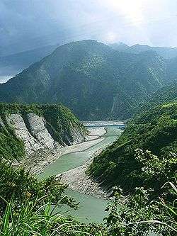 Xiuguluan River in Hualien | |
 | |
| Country | Taiwan |
| Physical characteristics | |
| Main source |
Mabolasi Mountain 3,000 m (9,800 ft) |
| River mouth |
Pacific Ocean 0 m (0 ft) |
| Length | 81.15 km (50.42 mi) |
| Discharge |
|
| Basin features | |
| Basin size | 1,790.46 km2 (691.30 sq mi) |
| Tributaries |
|
The Xiuguluan River (Chinese: 秀姑巒溪; Hanyu Pinyin: Xiùgūluán Xī; Tongyong Pinyin: Siòuguluán Si; Wade–Giles: Hsiu4-ku1-luan2 Hsi1; Pe̍h-ōe-jī: Siù-ko͘-lôan-khoe) is a river in southeastern Taiwan. It flows through the Huatung Valley for 81 km (50 mi) before emptying into the Pacific Ocean in Fengbin, Hualien.[1][2]
Overview
The river originates on the eastern side of Mabolasi Mountain (on the border with Taitung County) and flows through the Xiuguluan Mountain. It is the largest river in eastern Taiwan. Over 30 species of fish have been found in the river.[3]
Rafting
The river is known for its many rapids and has become a prime destination for rafting,[3] especially on a 24 km (15 mi) section Rueisuei Bridge to the Changhong Bridge.[4]
Tributaries
There are five major tributaries, listed here from mouth to source:[2]
- Fuyuan River – Hualien County – 28 km
- Hongye River – Hualien County – 16 km
- Fengping River – Hualien County – 19 km
- Lekuleku River – Hualien County – 54 km
See also
References
- ↑ "Geography & demographics". The Republic of China Yearbook 2015. Executive Yuan. 2015. pp. 40–53. ISBN 978-986-04-6013-1.
- 1 2 "Xiuguluan River basin". River System Introduction (in Chinese). The Ninth River Management Office, Water Resources Agency, Ministry of Economic Affairs. Retrieved 5 May 2016.
- 1 2 "Xiuguluan River". East Coast National Scenic Area Administration. Retrieved 2010-07-18.
- ↑ "Ruisui Rafting Tourist Center". East Rift Valley National Scenic Area. Retrieved 2010-07-18.
| Wikimedia Commons has media related to Xiuguluan River. |