Shingwedzi River
| Shingwedzi River (Xingwidzi or Tshingwedzi) | |
| Shingwedzirivier, Rio Singuédzi | |
| River | |
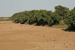 The dry bed of the Shingwedzi River in the Kruger National Park | |
| Name origin: Different meanings in the Venda language, among them "place of hard rock" and "dryness of area"[1] | |
| Country | South Africa and Mozambique |
|---|---|
| Provinces | Limpopo and Gaza |
| Source | ESE of Thohoyandou |
| - location | near Mtititi, Limpopo Province, South Africa |
| - elevation | 480 m (1,575 ft) |
| Mouth | Olifants River (Limpopo) |
| - location | Gaza Province, Mozambique |
| - elevation | 86 m (282 ft) |
| - coordinates | 23°53′32″S 32°17′8″E / 23.89222°S 32.28556°ECoordinates: 23°53′32″S 32°17′8″E / 23.89222°S 32.28556°E |
| Basin | 5,301 km2 (2,047 sq mi) |
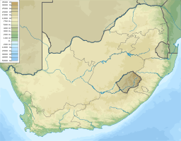 Location of the Shingwedzi River mouth | |
The Shingwedzi River, (Venda: Tshingwedzi; Tsonga: Xingwidzi; Afrikaans: Shingwedzirivier; Portuguese: Rio Singuédzi) is a river in Limpopo Province, South Africa and Gaza Province, Mozambique. It is a left hand tributary of the Olifants River (Rio dos Elefantes) and the northernmost river of its catchment area,[2] joining it at the lower end of its basin. The Shingwedzi is a seasonal river whose riverbed is dry for prolonged periods.[3]
Course
The Shingwedzi River drains the plain southeast of the Soutpansberg.[4] Its sources are about 40 km to the ESE of Thohoyandou. It flows eastwards across the lowveld and enters the area of the Kruger National Park.[5]
The main rivers of the Shingwedzi basin are the Mandzoro River, Mphongolo River, Phugwane River, Gole River, Shisha River, Tshamidzi River, Bububu River and the Dzombo River.[6]
Two dams on the river are located within the Kruger National Park near the Shingwedzi rest camp; the Kanniedood Dam and the Sirheni Dam.[7] The Makuleke Dam is in the Mphongolo River. After crossing into Mozambique, the river bends and flows southeastwards. Further downstream the Shingwedzi flows close to the northeastern side of the Massingir Dam's reservoir and joins the Olifants about 12 km down river from the dam wall.[8]
This river is a good place for observing large herds of African bush elephants, herds of 50 to 60 individuals being common in its basin.[9]
See also
References
- ↑ Transvaal Indigenous Place Names Archived 2008-10-31 at the Wayback Machine.
- ↑ "State of Rivers Report - The Olifants River System". Council for Scientific and Industrial Research. Archived from the original on 2007-07-03. Retrieved 2009-02-19.
- ↑ Shingwedzi River why is it the most polluted river in the KNP?
- ↑ Environmental Management Framework for the Olifants and Letaba Rivers Catchment area
- ↑ Luvuvu Lethaba WMA 2
- ↑ Rivers of the Kruger National Park... Perennial and Seasonal
- ↑ The Vulnerability of the Shingwedzi River, a Non-Perennial River in a Water Stressed Rural Area of the Limpopo Province, South Africa
- ↑ Shingwedzi River why is it the most polluted river in the KNP?
- ↑ Shingwedzi Rest Camp - Kruger National Park - SANParks
External links
| Wikimedia Commons has media related to Shingwedzi River. |