Shingave
| Shingave शिंगवे | |
|---|---|
| village | |
 Shingave Location in Maharashtra, India | |
| Coordinates: 19°47′56″N 74°33′23″E / 19.79889°N 74.55639°ECoordinates: 19°47′56″N 74°33′23″E / 19.79889°N 74.55639°E | |
| Country |
|
| State | Maharashtra |
| District | Ahmednagar |
| Taluka | Rahata |
| Government | |
| • Type | Panchayati raj |
| • Body | Grampanchayat |
| Population (2011) | |
| • Total | 4,258 |
| Demonym(s) | Shingavekar |
| Languages | |
| • Official | Marathi |
| Time zone | UTC+5:30 (IST) |
| PIN | 413708 |
| Telephone code | 02423 |
| Vehicle registration | MH-17 |
| Website | http://www.shingave-rahata.mahapanchayat.gov.in |
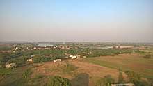
Shingave (Marathi: शिंगवे) is a village in Rahata taluka of Ahmednagar district in the Indian state of Maharashtra. It is one of the largest village by area in Rahata.
Location
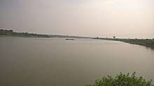
Shingave is situated on the bank of Godavari river in the northern region of Ahmednagar District.
Puntamba, Pimpalwadi, Sade, Rui and Wari are the nearby villages to Shingave. Shirdi, Rahata and Kopargaon are the nearby cities.[1]
Demographics
Population
The population of Shingave village is 4258 as of the 2011 census. Men constitute 2194 whereas women constitute 2064.[2]
Economy
Agriculture is a backbone of a village. Most of the people are farmers and some are marginal workers. Below table shows crops sown in village.
| Type | Crops |
|---|---|
| Kharif | Pearl millet, Maize, Soybean |
| Rabi | Wheat, Gram |
| Cash Crops | Sugarcane, Onion |
Education
Shingave has three Zilla Parishad primary schools and one secondary school.
- Primary schools
- ZP School (Central location)
- ZP School (West region)
- ZP School (East region)
- Secondary school
- Shringeshwar Madhyamik Vidyalaya
Transport
Road
Shingave is connected to nearby cities and villages by state highway (SH 36) and other rural roads. State highway connects Shingave to Kopargaon, Puntamba and Shrirampur, rural roads to Pimpalwadi, Rui, Wari and Shirdi.
Rail
Shingave is served by nearby Shirdi, Puntamba and Kanhegaon railway stations.
Air
Shirdi Airport is the nearest airport to village at distance of 25 km.
See also
References
- ↑ "OneFiveNine:Explore India". OneFiveNine. Retrieved 4 August 2017.
- ↑ "Census of India 2011". Census of India. Registrar General & Census Commissioner. Retrieved 4 August 2017.