Shell Knob Township, Barry County, Missouri
| Shell Knob Township | |
|---|---|
| Township | |
 | |
| Coordinates: 36°37′19″N 093°37′42″W / 36.62194°N 93.62833°WCoordinates: 36°37′19″N 093°37′42″W / 36.62194°N 93.62833°W | |
| Country | United States |
| State | Missouri |
| County | Barry |
| Area | |
| • Total | 39 sq mi (101.01 km2) |
| • Land | 36.92 sq mi (95.63 km2) |
| • Water | 2.08 sq mi (5.38 km2) 5.33% |
| Elevation[1] | 1,102 ft (336 m) |
| Population (2000) | |
| • Total | 1,181 |
| • Density | 32/sq mi (12.3/km2) |
| FIPS code | 29-67250[2] |
| GNIS feature ID | 0766269 |
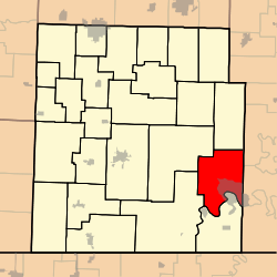
Shell Knob Township is one of twenty-five townships in Barry County, Missouri, United States. As of the 2000 census, its population was 1,181.
Some say the namesake Shell Knob has the name of one Mr. Shell, an early settler, while others believe deposits of shell fossils caused the name to be selected.[3]
Geography
Shell Knob Township covers an area of 39 square miles (100 km2) and contains no incorporated settlements. It contains one cemetery, Epperly Memorial.
The streams of Big Creek, Carter Branch, Cedar Branch, Kings River and Mill Creek run through this township.
Transportation
Shell Knob Township contains one airport or landing strip, Turkey Mountain Estates Airport.
References
- ↑ "US Board on Geographic Names". United States Geological Survey. 2007-10-25. Retrieved 2008-01-31.
- ↑ "American FactFinder". United States Census Bureau. Retrieved 2008-01-31.
- ↑ "Barry County Place Names, 1928-1945 (archived)". The State Historical Society of Missouri. Archived from the original on 24 June 2016. Retrieved 30 August 2016.
Notes
External links
Municipalities and communities of Barry County, Missouri, United States | ||
|---|---|---|
| Cities | 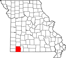 | |
| Villages | ||
| Townships | ||
| CDPs | ||
| Unincorporated communities | ||
| Ghost towns | ||
| Footnotes | ‡This populated place also has portions in an adjacent county or counties | |
This article is issued from
Wikipedia.
The text is licensed under Creative Commons - Attribution - Sharealike.
Additional terms may apply for the media files.