Pleasant Ridge Township, Barry County, Missouri
| Pleasant Ridge Township | |
|---|---|
| Township | |
 | |
| Coordinates: 36°54′01″N 093°47′19″W / 36.90028°N 93.78861°WCoordinates: 36°54′01″N 093°47′19″W / 36.90028°N 93.78861°W | |
| Country | United States |
| State | Missouri |
| County | Barry |
| Area | |
| • Total | 19.34 sq mi (50.08 km2) |
| • Land | 19.34 sq mi (50.08 km2) |
| • Water | 0 sq mi (0 km2) 0% |
| Elevation[1] | 1,480 ft (451 m) |
| Population (2000) | |
| • Total | 429 |
| • Density | 22.2/sq mi (8.6/km2) |
| FIPS code | 29-58484[2] |
| GNIS feature ID | 0766266 |
Pleasant Ridge Township is one of twenty-five townships in Barry County, Missouri, United States. As of the 2000 census, its population was 429.
Pleasant Ridge Township was organized in 1887 and named for a ridge within its borders.[3]
Geography
Pleasant Ridge Township covers an area of 19.34 square miles (50.1 km2) and contains no incorporated settlements. It contains one cemetery, Calton.
References
- ↑ "US Board on Geographic Names". United States Geological Survey. 2007-10-25. Retrieved 2008-01-31.
- ↑ "American FactFinder". United States Census Bureau. Retrieved 2008-01-31.
- ↑ "Barry County Place Names, 1928-1945 (archived)". The State Historical Society of Missouri. Archived from the original on 24 June 2016. Retrieved 30 August 2016.
External links
Municipalities and communities of Barry County, Missouri, United States | ||
|---|---|---|
| Cities | 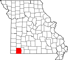 | |
| Villages | ||
| Townships | ||
| CDPs | ||
| Unincorporated communities | ||
| Ghost towns | ||
| Footnotes | ‡This populated place also has portions in an adjacent county or counties | |
This article is issued from
Wikipedia.
The text is licensed under Creative Commons - Attribution - Sharealike.
Additional terms may apply for the media files.