Shek Kong
| Shek Kong | |||||||||||||
 Shek Kong Airfield | |||||||||||||
| Traditional Chinese | 石崗 | ||||||||||||
|---|---|---|---|---|---|---|---|---|---|---|---|---|---|
| Simplified Chinese | 石岗 | ||||||||||||
| |||||||||||||
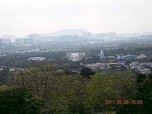
Shek Kong (Chinese: 石崗; literally: "Rock Hillock") is an area north of Tai Mo Shan, located near Kam Tin and Pat Heung, New Territories, Hong Kong.
Shek Kong Airfield is located in Shek Kong. A sizable Nepal Gurkha population presents in the area even after the withdrawal of British military.
| Wikimedia Commons has media related to Shek Kong. |
Climate
| Climate data for Shek Kong (1997–2016) | |||||||||||||
|---|---|---|---|---|---|---|---|---|---|---|---|---|---|
| Month | Jan | Feb | Mar | Apr | May | Jun | Jul | Aug | Sep | Oct | Nov | Dec | Year |
| Record high °C (°F) | 28.4 (83.1) |
30.5 (86.9) |
30.8 (87.4) |
33.1 (91.6) |
34.4 (93.9) |
36.4 (97.5) |
37.3 (99.1) |
37.2 (99) |
35.9 (96.6) |
34.2 (93.6) |
32.3 (90.1) |
29.6 (85.3) |
37.3 (99.1) |
| Average high °C (°F) | 19.8 (67.6) |
21.1 (70) |
23.6 (74.5) |
27.1 (80.8) |
29.8 (85.6) |
31.4 (88.5) |
32.5 (90.5) |
32.3 (90.1) |
31.3 (88.3) |
29.2 (84.6) |
25.6 (78.1) |
21.3 (70.3) |
27.1 (80.8) |
| Daily mean °C (°F) | 15.2 (59.4) |
16.9 (62.4) |
19.5 (67.1) |
23.3 (73.9) |
26.2 (79.2) |
28.0 (82.4) |
28.7 (83.7) |
28.3 (82.9) |
27.3 (81.1) |
25.1 (77.2) |
21.2 (70.2) |
16.8 (62.2) |
23.0 (73.4) |
| Average low °C (°F) | 11.5 (52.7) |
13.5 (56.3) |
16.2 (61.2) |
20.3 (68.5) |
23.3 (73.9) |
25.2 (77.4) |
25.6 (78.1) |
25.1 (77.2) |
24.2 (75.6) |
21.9 (71.4) |
17.7 (63.9) |
12.9 (55.2) |
19.8 (67.6) |
| Record low °C (°F) | 1.9 (35.4) |
3.1 (37.6) |
6.8 (44.2) |
10.8 (51.4) |
15.9 (60.6) |
19.2 (66.6) |
21.7 (71.1) |
21.7 (71.1) |
17.6 (63.7) |
12.5 (54.5) |
5.8 (42.4) |
2.5 (36.5) |
1.9 (35.4) |
| Average precipitation mm (inches) | 38.1 (1.5) |
35.1 (1.382) |
62.1 (2.445) |
141.4 (5.567) |
284.1 (11.185) |
423.0 (16.654) |
324.2 (12.764) |
345.7 (13.61) |
261.4 (10.291) |
71.7 (2.823) |
34.6 (1.362) |
34.1 (1.343) |
2,055.5 (80.925) |
| Average relative humidity (%) | 72 | 76 | 78 | 80 | 82 | 84 | 82 | 83 | 79 | 74 | 73 | 70 | 77 |
| Source: Hong Kong Observatory[1] | |||||||||||||
References
- ↑ "Monthly Means of Meteorological Elements for Shek Kong, 1997-2016". Hong Kong Observatory. Retrieved February 8, 2017.
This article is issued from
Wikipedia.
The text is licensed under Creative Commons - Attribution - Sharealike.
Additional terms may apply for the media files.