Line 2 (Shanghai Metro)
| Line 2 | |||
|---|---|---|---|
|
| |||
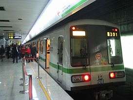 Line 2 AC02 series train at People's Square station. | |||
| Overview | |||
| Other name(s) | R2 (planned name) | ||
| Type | Rapid transit | ||
| System | Shanghai Metro | ||
| Status | Operational | ||
| Locale |
Pudong; Huangpu, Jing'an, Changning, Minhang, and Qingpu districts Shanghai | ||
| Termini |
East Xujing Pudong International Airport | ||
| Stations | 30 | ||
| Daily ridership | 1.87 million (2014 Peak)[1] | ||
| Operation | |||
| Opened | June 11, 2000 | ||
| Operator(s) | Shanghai No.2 Metro Operation Co., Ltd. | ||
| Character | Underground and elevated | ||
| Technical | |||
| Line length | 64 km (39.77 mi)[2] | ||
| Number of tracks | 2 | ||
| Track gauge | 1,435 mm (4 ft 8 1⁄2 in) | ||
| Electrification | Overhead lines (1500 volts) | ||
| Operating speed | 80 km/h (50 mph)[3] | ||
| |||
Line 2, Shanghai Metro | |||||||||||||||||||||||
|---|---|---|---|---|---|---|---|---|---|---|---|---|---|---|---|---|---|---|---|---|---|---|---|
| |||||||||||||||||||||||
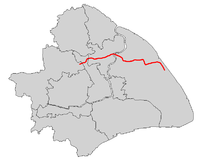
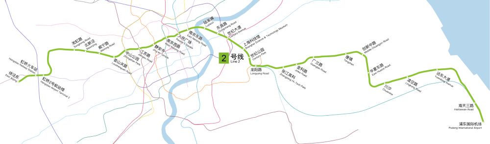
Line 2 is an east-west line of the Shanghai Metro network. With a length of nearly 64 km, it is the second longest line in the metro system after Line 11. Line 2 runs from East Xujing in the west to Pudong International Airport in the east, passing Hongqiao Airport, the Huangpu river, and the Lujiazui Financial District in Pudong. With a daily ridership of almost 1.5 million,[4] it is the Shanghai Metro's busiest metro line. The eastern portion of the line, from Guanglan Road to Pudong International Airport, operates independently from the main line. The line is colored light green on system maps.
Service routes
Stations
- Service
- AM - AM Rush hour (7:30AM–9:30AM on weekdays only)
- M - Mainline
- P - Partial Mainline
- A - Pudong Airport
| A M |
M | P | A | Station name | Connections | Distance km |
Location | ||
|---|---|---|---|---|---|---|---|---|---|
| English | Chinese | ||||||||
| ● | ● | East Xujing | 徐泾东 | 0.00 | 0.00 | Qingpu | |||
| ● | ● | Hongqiao Railway Station | 虹桥火车站 | 10 17 |
2.13 | 2.13 | Minhang | ||
| ● | ● | Hongqiao Airport Terminal 2 | 虹桥2号航站楼 | 10 |
0.51 | 2.64 | |||
| ● | ● | ● | Songhong Road | 淞虹路 | 5.69 | 8.33 | Changning | ||
| ● | ● | ● | Beixinjing | 北新泾 | 1.40 | 9.73 | |||
| ● | ● | ● | Weining Road | 威宁路 | 1.26 | 10.99 | |||
| ● | ● | ● | Loushanguan Road | 娄山关路 | 1.60 | 12.59 | |||
| ● | ● | ● | Zhongshan Park | 中山公园 | 3 4 | 1.68 | 14.27 | ||
| ● | ● | ● | Jiangsu Road | 江苏路 | 11 | 1.43 | 15.70 | ||
| ● | ● | ● | Jing'an Temple | 静安寺 | 7 |
1.13 | 16.83 | Jing'an | |
| ● | ● | ● | West Nanjing Road | 南京西路 | 12 13 [note 1] | 1.82 | 18.65 | ||
| ● | ● | ● | People's Square | 人民广场 | 1 8 | 1.21 | 19.86 | Huangpu | |
| ● | ● | ● | East Nanjing Road | 南京东路 | 10 | 1.14 | 21.00 | ||
| ● | ● | ● | Lujiazui | 陆家嘴 | 1.86 | 22.86 | Pudong | ||
| ● | ● | ● | Dongchang Road | 东昌路 | 1.30 | 24.16 | |||
| ● | ● | ● | Century Avenue | 世纪大道 | 4 6 9 | 1.27 | 25.43 | ||
| ● | ● | ● | Shanghai Science and Technology Museum | 上海科技馆 | 1.81 | 27.24 | |||
| ● | ● | ● | Century Park | 世纪公园 | 1.43 | 28.67 | |||
| ● | ● | ● | Longyang Road | 龙阳路 | 7 16 Maglev [note 2] | 1.09 | 29.76 | ||
| ● | ● | ● | Zhangjiang Hi-Tech Park | 张江高科 | 2.67 | 32.43 | |||
| ● | ● | ● | Jinke Road | 金科路 | 1.64 | 34.07 | |||
| ● | ● | ● | ● | Guanglan Road[note 3] | 广兰路 | 1.95 | 36.02 | ||
| ● | ● | Tangzhen[note 4] | 唐镇 | 3.38 | 39.40 | ||||
| ● | Middle Chuangxin Road | 创新中路 | 1.76 | 41.16 | |||||
| ● | East Huaxia Road | 华夏东路 | 2.13 | 43.29 | |||||
| ● | Chuansha | 川沙 | 3.17 | 46.46 | |||||
| ● | Lingkong Road | 凌空路 | 1.90 | 48.36 | |||||
| ● | Yuandong Avenue | 远东大道 | 3.11 | 51.47 | |||||
| ● | Haitiansan Road | 海天三路 | 5.91 | 57.38 | |||||
| ● | Pudong International Airport | 浦东国际机场 | Maglev [note 2] |
2.33 | 59.71 | ||||
History
The first section of Line 2 was opened in October 28, 1999, from Zhongshan Park to Longyang Road. This section, which included 12 stations, totaled 16.3 kilometres (10.1 mi). A year later, Zhangjiang Hi-Tech Park was added to the eastern part of the line, adding 2.8 kilometres (1.7 mi). Four new stations, located west of the Zhongshan Park station, opened in December 2006, extending the line to Songhong Road. This section added 6.15 kilometres (3.82 mi) to the line. Four years later, in preparation for the 2010 Shanghai World Expo, the line was significantly expanded. In February, the Zhangjiang Hi-Tech Park station was rebuilt. In addition, another eastern segment took Line 2 to Guanglan Road.[5][6][7] A month later, the line was extended westward to East Xujing, adding 8.0 kilometres (5.0 mi) to the line including a stop at Hongqiao Airport Terminal 2.[8] On April 8, an eastward extension added 8 stations to the line, totaling 26.6 kilometres (16.5 mi) and taking Line 2 to Pudong International Airport.[9][10] On July 1, Hongqiao Railway Station opens to the public with the opening of the railway station of the same name.
In October 2006, it was decided to rename three stations on Line 2 by the end of the year,[11][12] adopting a new naming scheme: metro stations, unlike bus stops, are no longer supposed to be named after neighbouring vertical streets, but famous streets and sights in the vicinity, making it easier for visitors to find these places. The renamed stations are Century Avenue (formerly Dongfang Road), East Nanjing Road (formerly Middle Henan Road) and West Nanjing Road (formerly Shimen No. 1 Road).
| Segment | Commencement | Length | Station(s) | Name |
|---|---|---|---|---|
| Zhongshan Park — Longyang Road | 11 June 2000 | 16.4 km (10.19 mi) | 12 | (initial phase) |
| Longyang Road — Zhangjiang Hi-Tech Park | 26 December 2000 | 2.8 km (1.74 mi) | 1 | Eastern extension (1st section) |
| Songhong Road — Zhongshan Park | 30 December 2006 | 6.8 km (4.23 mi) | 4 | 1st Western extension |
| Zhangjiang Hi-Tech Park — Guanglan Road | 24 February 2010 | 3.4 km (2.11 mi) | 2 | Eastern extension (2nd section) |
| East Xujing — Songhong Road | 16 March 2010 | 8.6 km (5.34 mi) | 2 | 2nd Western extension |
| Guanglan Road — Pudong International Airport | 8 April 2010 | 26.8 km (16.65 mi) | 8 | Eastern extension (3rd section) |
| Hongqiao Railway Station | 1 July 2010 | Infill station | 1 |
Route
East Xujing to West Nanjing Road
The line begins at East Xujing at the intersection of Xumin East Road and Zhuguang Road.[13][14] The line heads northeastward under Xumin East Road for about 0.8 kilometres (0.50 mi) before veering off the road and heading east, passing under Huaxiang Road. The line then enters the interchange station serving the Hongqiao Railway Station.[15] This station is an interchange with Line 10. Shortly thereafter, the line enters the Hongqiao Airport Terminal 2.[16] Line 2 then turns northward until it meets Tianshan Road and turns east again, roughly running parallel under Tianshan Road. Along this road, the line enters the Songhong Road,[17] Beixinjing,[18] and Weining Road stations.[19] At the Loushanguan Road, Line 2 veers away from Tianshan Road, heading northeastward.[20] The line then enters the Zhongshan Park along Changning Road, an interchange with lines 3 and 4.[21][22] The subway line then runs parallel under Changning Road for a short distance before heading east under Yuyuan Road. Along Yuyuan Road, there is a station at Jiangsu Road, an interchange to Line 11.[23][24] East of this station, the line swerves away from Yuyuan Road and runs under Yongyuan Road, which merges into West Nanjing Road, where Line 2 enters the Jing'an Temple, an interchange to Line 7.[25] Just before entering the West Nanjing Road, the metro line veers away from West Nanjing Road to Wujiang Road.[26] Line 2 comes back under the road shortly thereafter.
West Nanjing Road to Longyang Road
East of the West Nanjing Road, Line 2 heads eastward along West Nanjing Road, passing under the South-North Elevated Road. It then turns northeast into the People's Square,[27] and interchange with lines 1 and 8. East of the People's Square station, the subway line moves under East Nanjing Road to the East Nanjing Road.[28] Leaving the Huangpu District of Shanghai, the line heads under the Huangpu River and enters the Pudong New Area of Shanghai. The metro line passes the Oriental Pearl TV Tower and the World Finance Center near its station at Lujiazui. The line then runs under Century Avenue and heads southeastward to the Dongchang Road. Line 2 then heads to the Century Avenue, the largest interchange station that serves lines 4, 6 and 9 as well. Line 2 continues southeastward along Century Avenue to the Shanghai Science and Technology Museum. From here, the line turns southward through Century Park to the Century Park. From here, the line turns southeast and then east as it enters the Longyang Road, an interchange with Line 7 as well as the Shanghai Maglev Train.
Longyang Road to Pudong International Airport
From the Longyang Road, the metro line heads eastward. Line 2 heads eastward, running under Zuchongzhi Road to the Zhangjiang Hi-Tech Park station. The line heads northeastward under Zuchongzhi Road to the Jinke Road and Guanglan Road stations. Line 2 then veers away from Zuchongzhi Road and heads under the Waihuan Expressway to the Tangzhen and Middle Chuangxin Road stations, turning south. Heading southward, it heads through the East Huaxia Road and turns back east, running under Chuanhuan Road. Line 2 then passes through the Chuansha. Heading away from Chuanhuan Road, the metro line then enters the Lingkong Road and Yuandong Avenue stations along Huazhou Road before turning southeast. Line 2 then begins running parallel to the Shanghai Maglev Train as it runs under the Yingbin Expressway and enters the Haitiansan Road. From here, Line 2 continues south to its terminus at the Pudong International Airport, which serves Shanghai Pudong International Airport.
Technology
Power Supply
Siemens Transportation Systems equipped this line with an overhead contact line (cantilever material: galvanized steel) and 7 DC traction power supply substations.[29]
Rolling Stock
AC02A, AC08, and AC17a series trains operate from East Xujing - Guanglan Road while AC17b series trains operates from Guanglan Road - Pudong International Airport.
| Type | Time of manufacturing | Series | Sets | Assembly | Notes |
|---|---|---|---|---|---|
| Type A | 2000–2001 | 02A01 | 16 | Tc+Mp+M+Mp+M+Mp+M+Tc | Manufactured by Siemens AG and ADtranz |
| Type A | 2007–2009 | 02A02 | 21 | Tc+Mp+M+Mp+M+M+Mp+Tc | Manufactured by Alstom and CSR Puzhen |
| Type A | 2009–2010 | 02A03 | 16 | Tc+Mp+M+Mp+Mp+M+Mp+Tc | Manufactured by Alstom and CSR Puzhen |
| Type A | 2009–2010 | 02A04 | 16 | Tc+Mp+Mp+Tc (4 car set) Tc+Mp+Mp+M+Mp+M+Mp+Tc (8 car set) | Manufactured by Alstom and CSR Puzhen |
Notes
- ↑ Out of system transfer with Line 12 or Line 13.
- 1 2 Out of system transfer with Shanghai Maglev Train.
- ↑ The section west of Guanglan Road towards Hongqiao Airport is served by 8-carriaged trains that run at 3-minute intervals; while the section east of Guanglan Road towards Pudong International Airport is served by 4-carriaged trains that run at 6 to 8 minutes' interval from 6 am to 10 pm. Any trips that bypass Guanglan Road station requires passengers to transfer to the opposite platform at the station, except for some trains during the morning rush hour that operate between East Xujing and Tangzhen.
- ↑ Tangzhen is served by some 8-carriaged trains during rush hours only. All other trains stopping at this station are 4-carriaged trains that operate between Guanglan Road and Pudong International Airport.
References
- ↑ 12月31日客流破千万. Shanghai Metro. Retrieved 2015-06-19.
- ↑ "Operations Overview". Shanghai Metro Operation Co, Ltd. Archived from the original on 2011-11-09. Retrieved 2011-11-07.
- ↑ "Shanghai Metro Lines 1 & 2". Movia. Bombardier. Retrieved 2007-10-14.
- ↑ "Ridership". Sina. Retrieved 2012-05-03.
- ↑ Note that a new underground platform has been built at Zhangjiang station.
- ↑ Extension of Line 2 to Guanglan Road Archived 2010-07-10 at the Wayback Machine. Xinmin.cn, retrieved 24 February 2010
- ↑ Extension of Line 2 Eastday.com, retrieved 24 February 2010
- ↑ 上海地铁首次通入机场 虹桥机场2号航站楼将启用 Archived 2011-07-08 at the Wayback Machine., retrieved 15 March 2010
- ↑ 轨道交通2号线东延伸二期 4月8日连通浦东国际机场, retrieved 7 April 2010
- ↑ 2号线明起通至浦东国际机场, retrieved 7 April 2010
- ↑ Three Metro station names will be changed, Shanghai Daily, 21 October 2006
- ↑ 'Shiji Avenue' new Metro station name, Shanghai Daily, 21 October 2006
- ↑ Google (February 15, 2011). "Xujing East station" (Map). Google Maps. Google. Retrieved February 15, 2011.
- ↑ Mayer, Matt. "East Xujing". Retrieved February 15, 2011.
- ↑ Google (February 15, 2011). "Shanghai Hongiao Railway Station" (Map). Google Maps. Google. Retrieved February 15, 2011.
- ↑ Google (February 15, 2011). "Honqiao Airport Terminal 2 station" (Map). Google Maps. Google. Retrieved February 15, 2011.
- ↑ Google (February 15, 2011). "Songhong Road station" (Map). Google Maps. Google. Retrieved February 15, 2011.
- ↑ Google (February 15, 2011). "Beixinjing station" (Map). Google Maps. Google. Retrieved February 15, 2011.
- ↑ Google (February 15, 2011). "Weining Road station" (Map). Google Maps. Google. Retrieved February 15, 2011.
- ↑ Google (February 15, 2011). "Loushanguan Road station" (Map). Google Maps. Google. Retrieved February 15, 2011.
- ↑ Google (February 15, 2011). "Zhongshan Park station" (Map). Google Maps. Google. Retrieved February 15, 2011.
- ↑ Mayer, Matt. "Zhongshan Park". Retrieved February 15, 2011.
- ↑ Google (February 15, 2011). "Jiangsu Road station" (Map). Google Maps. Google. Retrieved February 15, 2011.
- ↑ Mayer, Matt. "Jiangsu Road". Retrieved February 15, 2011.
- ↑ Google (February 15, 2011). "Jing'an Temple station" (Map). Google Maps. Google. Retrieved February 15, 2011.
- ↑ Google (February 15, 2011). "West Nanjing Road station" (Map). Google Maps. Google. Retrieved February 15, 2011.
- ↑ Google (February 19, 2011). "People's Square station" (Map). Google Maps. Google. Retrieved February 19, 2011.
- ↑ Google (February 19, 2011). "East Nanjing Road station" (Map). Google Maps. Google. Retrieved February 19, 2011.
- ↑ Metro-System Line 2, Shanghai, China Archived 2009-06-28 at the Wayback Machine., retrieved July 6, 2008.
Public transportation in Shanghai Metropolitan Area (SH) | |||||||
|---|---|---|---|---|---|---|---|
| |||||||
| |||||||
| |||||||
| |||||||
| Other urban systems |
| ||||||
| Transportation hubs | |||||||
| |||||||
| Line 2 |
|
|---|---|