Seventy Six, Kentucky
| Seventy Six, Kentucky | |
|---|---|
| Unincorporated community | |
 Seventy Six, Kentucky | |
| Coordinates: 36°47′11″N 85°08′38″W / 36.78639°N 85.14389°WCoordinates: 36°47′11″N 85°08′38″W / 36.78639°N 85.14389°W | |
| Country | United States |
| State | Kentucky |
| County | Clinton |
| Elevation | 958 ft (292 m) |
| Time zone | UTC-6 (Central (CST)) |
| • Summer (DST) | UTC-5 (CDT) |
| Area code(s) | 606 |
| GNIS feature ID | 509034[1] |
Seventy Six is an unincorporated community in Clinton County, Kentucky, United States. Seventy Six is 6.9 miles north of Albany. Its post office [2] has been closed.
The community was named after nearby Seventy Six Falls.[3]
See also
References
- ↑ "US Board on Geographic Names". United States Geological Survey. 2007-10-25. Retrieved 2008-01-31.
- ↑ U.S. Geological Survey Geographic Names Information System: Seventy Six KY post office
- ↑ Moyer, Armond; Moyer, Winifred (1958). The origins of unusual place-names. Keystone Pub. Associates. p. 118.
Municipalities and communities of Clinton County, Kentucky, United States | ||
|---|---|---|
| City | 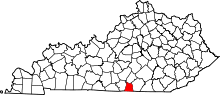 | |
| Unincorporated communities |
| |
| Footnotes | ‡This populated place also has portions in an adjacent county or counties | |
This article is issued from
Wikipedia.
The text is licensed under Creative Commons - Attribution - Sharealike.
Additional terms may apply for the media files.