Servian Wall
| Servian Wall | |
|---|---|
| Rome, Italy | |
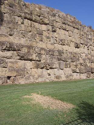 A preserved section of Servian Wall next to Termini railway station. | |
 A map of Rome showing the Servian Wall (blue) and its gates. The Aurelian Walls (red) were constructed in the 3rd century AD. | |
| Type | Defensive wall |
| Height | Up to 10 metres (33 ft) |
| Site information | |
| Open to the public | Open to public. |
| Condition | Ruinous. Fragmentary remains |
| Site history | |
| Built | 4th century BC |
| Materials | Tuff |
| Events | Second Punic War |
| Garrison information | |
| Occupants | Romans |
The Servian Wall (Latin: Murus Servii Tullii; Italian: Mura Serviane) was an ancient Roman defensive barrier constructed around the city of Rome in the early 4th century BC. The wall was up to 10 m (33 ft) in height in places, 3.6 m (12 ft) wide at its base, 11 km (6.8 mi) long,[1] and is believed to have had 16 main gates. In the 3rd century AD it was superseded by the construction of the larger Aurelian Walls.
History
The wall is named after the sixth Roman King, Servius Tullius. Although its outline may go back to the 6th century BC, the currently extant wall was built in the 4th c., during the Roman Republic, in response to the sack of Rome after the Battle of the Allia by the Gauls of Brennus.
Construction
The wall was built from large blocks of tuff (a volcanic rock made from ash and rock fragments ejected during an eruption) quarried from the Grotta Oscura quarry near Rome's early rival Veii, presumably after its defeat by Rome in the 390s.[2] In addition to the blocks, some sections of the structure incorporated a deep fossa, or ditch, in front of it, as a means to effectively heighten the wall during attack from invaders.
Along part of its topographically weaker northern perimeter was an agger, a defensive ramp of earth heaped up to the wall along the inside. This thickened the wall, and also gave defenders a base to stand while repelling any attack. The wall was also outfitted with defensive war engines, including catapults.
Usage
The Servian Wall was formidable enough to repel Hannibal during the Second Punic War. Hannibal famously invaded Italy across the Alps with elephants, and had crushed several Roman armies in the early stages of the war. However, the wall was never put to the test as Hannibal only once, in 211 BC, brought his Carthaginian army to Rome as part of a feint to draw the Roman army from Capua. When it was clear that this had failed, he turned away, without approaching closer than 3 mi (4.8 km) to Rome, as a Roman army sallied out of the Servian walls and pitched a camp next to Hannibal's. During the Roman civil wars, the Servian walls were repeatedly overrun.
The wall was still maintained through the end of the Republic and in the early Empire. By this time, Rome had already begun to grow outside the original Servian Wall. The organization of Rome into regions under Augustus placed regions II, III, IV, VI, VIII, X, and XI within the Servian Wall, with the other sections outside of it.
The wall became unnecessary as Rome became well protected by the ever-expanding military strength of the Republic and of the later Empire. As the city continued to grow and prosper, it was essentially unwalled for the first three centuries of the Empire. When German tribes made further incursions along the Roman frontier in the 3rd century AD, Emperor Aurelian had the larger Aurelian Walls built to protect Rome.[3]
Present day
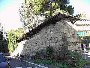
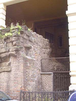
Sections of the Servian Wall are still visible in various locations around Rome. The largest section is preserved just outside Termini Station, the main railway station in Rome (including a small piece in a McDonald's dining area at the station). Another notable section on the Aventine incorporates an arch for a defensive catapult from the late Republic.
Gates along the Servian Wall
The following lists the gates that are believed to have been built, clockwise from the westernmost. (Many of these are inferred only from writings, with no known remains.)
- Porta Flumentana – this gate was where the via Aurelia entered Rome after crossing the Tiber River.
- Porta Carmentalis – the western end of the Capitoline.
- Porta Fontinalis – led from the northern end of the Capitoline into the Campus Martius along the via Lata.
- Porta Sanqualis – on the Quirinal.
- Porta Salutaris – on the Quirinal.
- Porta Quirinalis – on the Quirinal.
- Porta Collina – the northernmost gate, on the Quirinal, leading to the via Salaria. Hannibal camped his army within sight of this gate when he considered besieging Rome in 211 BC. This section was fortified additionally with the agger.
- Porta Viminalis – on the Viminal. This is near the large section still visible outside Termini Station.
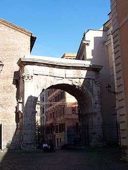
- Porta Esquilina – this gate on the Esquiline is still visible, and incorporates the later arch of the emperor Gallienus. It led to the via Labicana, via Praenestina and via Tiburtina.
- Porta Querquetulana – this led to the via Tusculana.
- Porta Caelimontana – this gate is perhaps preserved in the Arch of Dolabella and Silanus, which was the reconstruction of an existing gate in 10 AD by the consuls Dolabella and Silanus.
- Porta Capena – this was the gate through which the via Appia left Rome to southern Italy after separating from the via Latina.
- Porta Naevia – this gate on the Aventine led to the via Ardeatina.
- Porta Raudusculana – headed south along the Tiber River along the via Ostiensis. Near here, on the modern viale Aventino, may be found a section of the wall incorporating an arch for a catapult.
- Porta Lavernalis – also joined up with the via Ostiensis.
- Porta Trigemina – this triple gate near the Forum Boarium also led to the via Ostiensis.
See also
References
- ↑ Fields, Nic; Peter Dennis The Walls of Rome Osprey Publishing; 10 Mar 2008 ISBN 978-1-84603-198-4 p.10.
- ↑ Tenney Frank (1924). The Letters on the Blocks of the Servian Wall.
- ↑ Watson, pp. 51–54, 217.
Bibliography
- Watson, Alaric (1999). Aurelian and the Third Century. Routledge. ISBN 0-415-07248-4.
- Coarelli, Filippo (1989). Guida Archeologica di Roma. Arnoldo Mondadori Editore, Milano.
External links
| Wikimedia Commons has media related to Servian Wall. |
- Servian Wall entry on the Lacus Curtius website
- Lacus Curtius page including gates in the Servian Wall
- Map showing the "Servian" wall based on new research results
Coordinates: 41°54′06″N 12°30′06″E / 41.90167°N 12.50167°E