Serranía de Chiribiquete
| Serranía de Chiribiquete | |
|---|---|
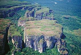 Aerial view of Chiribiquete | |
| Highest point | |
| Peak | Cerro Chiribiquete |
| Elevation | 800 m (2,600 ft) |
| Coordinates | 1°19′39″N 72°45′41″W / 1.32750°N 72.76139°WCoordinates: 1°19′39″N 72°45′41″W / 1.32750°N 72.76139°W |
| Dimensions | |
| Length | 125 km (78 mi) |
| Width | 30 km (19 mi) |
| Geography | |
 Serranía de Chiribiquete Location in Colombia
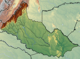 | |
| Country | Colombia |
| State/Province | Caquetá, Guaviare |
| Official name | Chiribiquete National Park – “The Maloca of the Jaguar” |
| Type | Cultural and Natural |
| Criteria | (iii), (ix), (x) |
| Designated | 2018 |
| Reference no. | 1174 |
| State Party |
|
| Region | South America |
The Serranía de Chiribiquete or Chiribiquete Mountains are a group of isolated table mountains in the Amazon Region of Colombia. The mountains are part of the western edge of the Guiana Shield.[1] The area is protected as a national park. This area is habitat for the Chiribiquete emerald (Chlorostilbon olivaresi), an endemic hummingbird. The waterfall Caño Paujil originates from the Serranía de Chiribiquete.[2]
Protected area
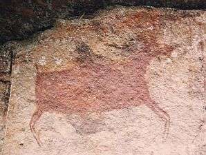
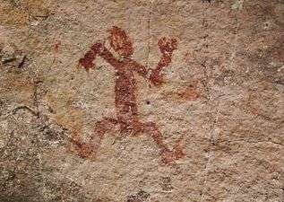
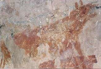
Chiribiquete National Park is the largest national park in Colombia and the largest tropical rainforest national park in the world. It covers about 43,000 km2 (17,000 sq mi) and hosts important archaeological evidence in the form of rock art.[3] More than 600,000 traces of around 20,000 petroglyphs and pictographs have been discovered in the mountain chain, the oldest of which may date to 20,000 years BP. The rock art has been produced until the 16th century. The rock paintings were first recorded by the American botanist Richard Evans Schultes in the 1940s. Later investigations were carried out by Thomas van der Hammen.[4]
British wildlife filmmaker Mike Slee Mike Slee and Colombian photographer and explorer Francisco Forero Bonell photographed and filmed the rock paintings on the vertical rock faces within the park in 2014. Serranía de Chiribiquete is featured in the 2015 documentary Colombia, magia salvaje, which was made by Mike Slee.[5]
Colombian president Juan Manuel Santos announced that Chiribiquete National Natural Park would be expanded by 15,000 km2 (5,800 sq mi) on 21 February, 2018.[6] The park was expanded to 43,000 km2 (17,000 sq mi) and declared a World Heritage site by UNESCO on 2 July, 2018.[3][7]

References
- ↑ Chiribiquete National Park Archived 2013-10-10 at the Wayback Machine.
- ↑ (in Spanish) Caño Paujil - Colparques
- 1 2 "Colombia's Serranía de Chiribiquete is now the world's largest tropical rainforest national park". World Wide Fund for Nature. 2 July 2018. Retrieved 3 July 2018.
- ↑ (in Spanish) Hallado tesoro arqueológico en el Parque Natural Chiribiquete - El Tiempo
- ↑ Alberge, Dalya (20 June 2015). "World's most inaccessible art found in the heart of the Colombian jungle". The Guardian. Retrieved 3 July 2018.
- ↑ Alsema, Adriaan (22 February 2018). "Colombia's biggest national park to become 1.5 million hectares bigger". Colombia Reports. Retrieved 3 July 2018.
- ↑ "Four sites added to UNESCO's World Heritage List". UNESCO. 1 July 2018. Retrieved 3 July 2018.
Mountain ranges of Colombia | ||||||||||
|---|---|---|---|---|---|---|---|---|---|---|
| Colombian Andes |
| .svg.png) | ||||||||
| Isolated ranges | ||||||||||