Sepik
| Sepik | |
| River | |
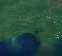 Sediment plumes at the mouth of the Sepik (right) and Ramu (left) rivers | |
| Countries | Papua New Guinea, Indonesia |
|---|---|
| Regions | Sandaun, Papua, East Sepik |
| Tributaries | |
| - left | Yellow River |
| - right | April River, Karawari, Yuat, Keram |
| Source | |
| - location | Victor Emanuel Range, Papua New Guinea |
| - elevation | 2,170 m (7,119 ft) |
| - coordinates | 5°13′S 141°49′E / 5.217°S 141.817°E |
| Mouth | |
| - location | Bismarck Sea, Papua New Guinea |
| - elevation | 0 m (0 ft) |
| - coordinates | 3°50′30″S 144°32′30″E / 3.84167°S 144.54167°ECoordinates: 3°50′30″S 144°32′30″E / 3.84167°S 144.54167°E |
| Length | 1,126 km (700 mi) |
| Basin | 80,321 km2 (31,012 sq mi) [1] |
| Discharge | |
| - average | 3,804 m3/s (134,337 cu ft/s) |
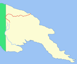 Location of the Sepik River in red (Fly River in blue) | |
The Sepik River (/ˈseɪpɪk/) is the longest river on the island of New Guinea, and after the Fly and the Mamberamo the third largest by volume.[2] The majority of the river flows through the Papua New Guinea (PNG) provinces of Sandaun (formerly West Sepik) and East Sepik, with a small section flowing through the Indonesian province of Papua.
The Sepik has a large catchment area, and landforms that include swamplands, tropical rainforests and mountains. Biologically, the river system is often said to be possibly the largest uncontaminated freshwater wetland system in the Asia-Pacific region.[3] But, in fact, numerous fish and plant species have been introduced into the Sepik since the mid-20th century.
From the headwaters to the mouth, the river flows through at least 12 different Sepik languages,[4] each corresponding to one or more culture regions of related villages that exhibit similar social characteristics. The largest language and culture group along the river is the Iatmul people.
Name
In 1884, Germany asserted control over the northeast quadrant of the island of New Guinea, which became part of the German colonial empire. The colony was initially managed by the Deutsche Neuguinea-Kompagnie or German New Guinea Company, a commercial enterprise that christened the territory Kaiser-Wilhelmsland. The first European ship to enter the Sepik estuary was the Samoa in May 1885. But the river, in fact, did not yet have a European name. It was thus termed Kaiserin Augustafluß by the explorer and scientist Otto Finsch, after the German Empress Augusta.
The word 'Sipik' was first reported by A. Full[5] as one of two names for the watercourse—the other being 'Abschima'—used by the natives living at the mouth of the river. A few years later, Leonhard Schultze applied the term 'Sepik' to the entire watercourse, and it took, although Schultze also noted another name for the river, 'Azimar'.[6] William Churchill, writing in the Bulletin of the American Geographical Society, wrote "These are not names of the river, they are but names for small stretches of the river as known to the folk of this or that hamlet. We cannot reckon how many such names there may be in the course of more than 600 miles of the system." Since "there is no indigenous name for the whole stream", Mr, Churchill concluded that "This is clearly a case where a European designation may properly be applied." He advocated for Kaiserin-Augusta. But that name faded with the German loss of colonial control over the territory after World War One. The word "Sepik" henceforth became the official name of the river.
Of course, each language group had one or more of its own names for the river. For example, the Iatmul people call the river "Avusett", a compound of "bone" (ava) and "lake" (tset).[7]
Description
The river originates in the Victor Emanuel Range in the central highlands of Papua New Guinea. From its mountain headwaters near Telefomin, it travels north-west and leaves the mountains abruptly near Yapsei. From here it flows into Indonesian Papua, before turning back north-east for the majority of its journey following the great Central Depression. Along its course it receives numerous tributaries from the Bewani and Torricelli Mountains to the north and the Central Range to the south, including the Yuat River formed by the Lai and the Jimmi.[8]
For most of the Sepik's length the river winds in serpentine fashion, like the Amazon River, to the Bismarck Sea off northern Papua New Guinea. Unlike many other large rivers, the Sepik has no delta whatsoever, but flows straight into the sea, about 100 kilometres (60 mi) east of the town of Wewak. It is also navigable for most of its length.
The river's total length is 1,126 kilometres (700 mi) and has a drainage basin of over 80,000 km2 (31,000 sq mi).[1] There is a 5-10 kilometres wide belt of active meanders formed by the river along most of its course that has created a floodplain up to 70 kilometres wide with extensive backwater swamps.[3] There are around 1,500 Oxbow and other lakes in the floodplain, the largest of which are the Chambri Lakes.[3]
The Sepik basin is largely an undisturbed environment, as there are no major urban settlements or mining and forestry activities in the river catchment. April Salome Forest Management Area is located in Sepik river basin.
History
Local villagers have lived along the river for many millennia and the river has formed the basis for food, transport and culture. There are at least 100 distinct villages and hamlets along the river, and most likely more.[9]
Exploration
European contact with the river started in 1885 when the Germans as part of establishing German New Guinea explored the area. The river was named by Dr Otto Finsch, Kaiserin Augusta, after the German Empress Augusta.[10] Upon finding the river, Finsch navigated about 50 kilometres (31 mi) upstream from its mouth.[10]
In 1886 and 1887, further expeditions by steam boat were conducted by the Germans and over 600 kilometres (370 mi) were explored.[10] Between 1912 and 1913 the Germans sent further expeditions to explore the river and surrounding areas. They collected flora and fauna, studied local tribes and produced the first maps. The station town of Angoram was established as a base on the lower Sepik for explorations, but with the beginning of World War I, the explorations ceased.[10]
After the first World War the Australian government took trusteeship of the German colony, creating the Territory of New Guinea, and the Sepik region came under their jurisdiction. During this period the Australians established a station on the middle Sepik at Ambunti to conduct further explorations.[10]
In 1923 journalist Beatrice Grimshaw attached herself to an expedition, and claimed to be the first white woman to ascent the Sepik, commenting on the widespread use of "Tok Pisinpidgen-English" as a lingua franca.[11] In 1935 Sir Walter McNicoll's the new administrator of the Territory of New Guinea travelled up length of the Sepik to "have a look at the river people and the kind of country along the banks".[12]
In 2010 Clark Carter and Andrew Johnson travelled the length of the Sepik River from source to sea. They hiked to the source from Telefomin and kayaked down the upper reaches in an inflatable kayak. After nearly drowning in a section of rapids near Telefomin, they decided to walk through the jungle, following the river until it was calm enough to take a dugout canoe the remaining 900 kilometres to the Bismarck Sea. The expedition took six weeks.
World War II
The Japanese held the area throughout most of the Second World War. By the end of the war though, the Japanese had been completely surrounded after Hollandia in Netherlands New Guinea was captured in April 1944 during Operations Reckless and Persecution and Aitape had fallen during the campaign in August 1944. The battle to defeat the remaining forces by the Australian Army was hard fought and drawn out due to the terrain.
The Australians eventually pushed the Japanese back to the village of Timbunke on the middle Sepik in July 1945. After an Australian RAAF plane landed 10 kilometres (6 mi) from Timbunke the Japanese suspected that the villagers had collaborated with the Australians and proceeded to massacre 100 of the villagers.[13]
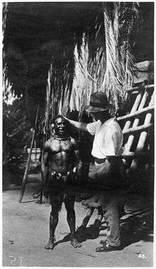
Sepik art
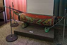
The tribes living along the river produce magnificent wood carvings, clay pottery and other art and craft within the broader traditions of New Guinea art. Many tribes use garamut drums in rituals; the drums are formed from long, hollowed-out tree trunks carved into the shape of various totem animals.[14][15][16]
Image gallery
 Korogo Village, Sepik River, PNG, 1975. Franz Luthi
 A warm welcome to foreign visitors
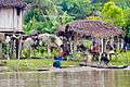 Snapshot of the daily life of the villagers
References
- 1 2 "OC05 Sepik". Water Resources eAtlas. Watersheds of the World. Archived from the original on 2007-12-14.
- ↑ Fragmentation and Flow Regulation of the World’s Large River Systems
- 1 2 3 "Sepik River". Rainbow Habitat. Archived from the original on 2007-05-31.
- ↑ Laycock, Donald C. (1965). The Ndu language family (Sepik District, New Guinea). Canberra: Australian National University. OCLC 810186.
- ↑ Full, A. 1909. "Eine Fahrt auf dem Kaiserin Augustafluß". Deutsches Kolonialblatt: Amtsblatt für die Schutzgebiete in Afrika und in der Südsee 20 (15) 739-41; 744–745.
- ↑ Schultz, Leonhard. 1914. Forschungen im Innern der Insel Neuginea: Bericht des Führers über die wissenschaftlichen Ergebnisse der deutschen Grenzexpedition in das westliche Kaiser-Wilhelmsland 1910. Berlin: E. S. Mittler.
- ↑ Silverman, Eric K. 2018. "The Sepik River, Papua New Guinea: Nourishing Tradition and Modern Catastrophe", in John R. Wagner and Jerry K. Jacka, eds., Island Rivers: Fresh Water and Place in Oceania, pp. 187–221, Canberra: ANU Press.
- ↑ Van Deusen, Hobart M.; George, Graeme G. (1969). "Results of the Archbold Expeditions. No. 90: Notes on the echidnas (Mammalia, Tachyglossidae) of New Guinea" (PDF). American Museum Novitates (2383). hdl:2246/2593.
- ↑ Still the best, most detailed map the river and region is Wewak: The Gateway to the Sepik: Maps of Wewak, West and East Sepik Provinces, published by Wirui Press, Wewak, Papua New Guinea, in the 1980s.
- 1 2 3 4 5 Lipscomb, Adrian; et al. (February 1998). Papua New Guinea (6 ed.). Lonely Planet. pp. 249–252. ISBN 0-86442-402-7.
- ↑ Hoehn, Matthew, ed., 1948, Catholic Authors Contemporary Biographical Sketches, 1930-1947: Newark, NJ, St. Marys Abbey, p. 293-295, cited on "Grimshaw Origin" accessed 6 August 2016
- ↑ McCarthy, J.K. (1963). Patrol into yesterday. Melbourne: F.W Cheshire Pty Ltd. pp. 139–149. ISBN 0-7015-0327-0.
- ↑ "Chapter Seven: Voices from Asia and the Pacific". War Compensation Forum. Archived from the original on 2011-09-28.
- ↑ "Amazon.com listing for the "Four Corners: A Journey into the Heart of Papua New Guinea"".
- ↑ Salak, Kira. "Nonfiction book about Papua New Guinea,"Four Corners"".
- ↑ Salak, Kira. "Includes photos of Art of Sepik River, Papua New Guinea".
External links
- The Sepik–Ramu System
- https://web.archive.org/web/20051020083352/http://www.pacificislandtravel.com/png/about_destin/sepik.html
- http://www.art-pacific.com/artifacts/nuguinea/sepikriv/sepikmrv.htm
- http://www.ewaoceanicgallery.com/sepik_river_region.html
- A Report on the Sepik River Basin
- Papua New Guinea Sepik River Video
- The Sepik River Expedition 2010