Senftenberg
| Senftenberg | ||
|---|---|---|
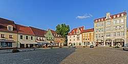 Market Square | ||
| ||
 Senftenberg Location of Senftenberg within Oberspreewald-Lausitz district  | ||
| Coordinates: 51°31′N 14°01′E / 51.517°N 14.017°ECoordinates: 51°31′N 14°01′E / 51.517°N 14.017°E | ||
| Country | Germany | |
| State | Brandenburg | |
| District | Oberspreewald-Lausitz | |
| Government | ||
| • Mayor | Andreas Fredrich (SPD) | |
| Area | ||
| • Total | 127.56 km2 (49.25 sq mi) | |
| Elevation | 102 m (335 ft) | |
| Population (2017-12-31)[1] | ||
| • Total | 24,558 | |
| • Density | 190/km2 (500/sq mi) | |
| Time zone | CET/CEST (UTC+1/+2) | |
| Postal codes | 01945 (Peickwitz), 01968 (Brieske, Großkoschen, Niemtsch, Sedlitz, Senftenberg), 01996 (Hosena) | |
| Dialling codes | 03573, 035756 (Hosena, Peickwitz) | |
| Vehicle registration | OSL, CA, SFB | |
| Website | www.senftenberg.de | |

Senftenberg (Sorbian languages: Zły Komorow) is a town in southern Brandenburg, Germany, capital of the Oberspreewald-Lausitz district. The river Schwarze Elster runs through Senftenberg and the town is located on the shores of Senftenberger See (Senftenberg Lake), one of the largest artificial lakes in Germany.
Geography
Senftenberg is located in the southwest of the historic Lower Lusatia region at the border with Saxony. Its town centre is situated north of the river Black Elster and the artificial Senftenberger Lake, part of the Lusatian Lake District chain, approximately 20 kilometres (12 mi) northwest of Hoyerswerda, and 35 kilometres (22 mi) southwest of Cottbus.
Senftenberg station is north of the centre and a major railway freight yard is located to its north-east, with a locomotive depot.
History
![]()
![]()
![]()
![]()
![]()
![]()
![]()
![]()
![]()
Senftenberg was first mentioned in a 1279 deed issued by Henry III the Illustrious of Wettin, then margrave of Lusatia. With Lower Lusatia, the settlement was acquired by the Kingdom of Bohemia under Charles IV of Luxembourg in 1368. Elector Frederick II of Saxony acquired Senftenberg in 1448, whereafter the area as a border stronghold of the House of Wettin was separated from Bohemian Lusatia, until in 1635 all Lusatian territories fell to Saxony by the Peace of Prague. According to the 1815 Congress of Vienna, Lower Lusatia was annexed by Prussia and incorporated into the Province of Brandenburg.
Names
- Czech: Zlý Komorov
- German: Senftenberg
- Polish: Zły Komorów
- Upper Sorbian: Zły Komorow
- Lower Sorbian: Zły Komorow
International relations
Senftenberg is twinned with:
Tourism
Lake "Senftenberger See"
The Senftenberger See (Senftenberger Lake) is a popular destination for both day trips and holiday. In 1973, the former open cast mine, was officially opened to the public. Today, the lake is known for its excellent water quality. It is part of the socalled Lusatian Lakeland, a group of 23 artificial lakes.
Demography
After the second half of the 19th century the inhabitants increased because of workers coming to Senftenberg to work in the coal mines. After the German Reunion, many inhabitants moved to the western part of Germany.
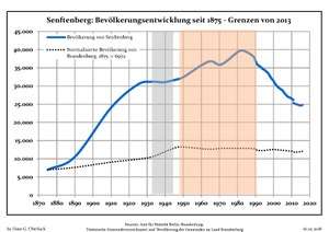 Development of Population since 1875 within the Current Boundaries (Blue Line: Population; Dotted Line: Comparison to Population Development of Brandenburg state; Grey Background: Time of Nazi rule; Red Background: Time of Communist rule)
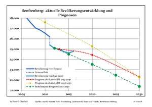 Recent Population Development (Blue Line) and Forecasts
| Senftenberg: Population development within the current boundaries (2013)[2] | |||||||||||||||||||||||||||||||||||||||||||||||||||||||||||||||||||||||||||||||||||||||||||||||||||||||||||||||||||||||||||||||||||||||||||||||||||||||||||
|---|---|---|---|---|---|---|---|---|---|---|---|---|---|---|---|---|---|---|---|---|---|---|---|---|---|---|---|---|---|---|---|---|---|---|---|---|---|---|---|---|---|---|---|---|---|---|---|---|---|---|---|---|---|---|---|---|---|---|---|---|---|---|---|---|---|---|---|---|---|---|---|---|---|---|---|---|---|---|---|---|---|---|---|---|---|---|---|---|---|---|---|---|---|---|---|---|---|---|---|---|---|---|---|---|---|---|---|---|---|---|---|---|---|---|---|---|---|---|---|---|---|---|---|---|---|---|---|---|---|---|---|---|---|---|---|---|---|---|---|---|---|---|---|---|---|---|---|---|---|---|---|---|---|---|---|
|
|
| |||||||||||||||||||||||||||||||||||||||||||||||||||||||||||||||||||||||||||||||||||||||||||||||||||||||||||||||||||||||||||||||||||||||||||||||||||||||||
Photogallery
 Senftenberg
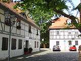
(Old Town)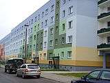 Estate housing
 Lutheran church
in "Jüttendorf"
See also
References
- ↑ "Bevölkerung im Land Brandenburg nach amtsfreien Gemeinden, Ämtern und Gemeinden 31. Dezember 2017 (Fortgeschriebene amtliche Einwohnerzahlen auf Grundlage des Zensus 2011)". Amt für Statistik Berlin-Brandenburg (in German). 2018.
- ↑ Detailed data sources are to be found in the Wikimedia Commons.Population Projection Brandenburg at Wikimedia Commons
External links
- Official website

![]()
Towns and municipalities in Oberspreewald-Lausitz | ||
|---|---|---|