Selenography

Selenography is the study of the surface and physical features of the Moon. Historically, the principal concern of selenographists was the mapping and naming of the lunar maria, craters, mountain ranges, and other various features. This task was largely finished when high resolution images of the near and far sides of the Moon were obtained by orbiting spacecraft during the early space era. Nevertheless, some regions of the Moon remain poorly imaged (especially near the poles) and the exact locations of many features (like crater depths) are uncertain by several kilometers. Today, selenography is considered to be a subdiscipline of selenology, which itself is most often referred to as simply "lunar science." The word selenography is derived from the Greek lunar deity Σελήνη Selene and γράφω graphō, "I write".
History
The idea that the Moon is not perfectly smooth originates to at least circa 450 BC, when Democritus asserted that the Moon had "lofty mountains and hollow valleys". However, not until the end of the 15th century AD did serious study of selenography began. Circa AD 1603, William Gilbert made the first lunar drawing based on naked-eye observation. Others soon followed, and when the telescope was invented, initial drawings of poor accuracy were made, but soon thereafter improved in tandem with optics. In the early 18th century, the librations of the Moon were measured, which revealed that more than half of the lunar surface was visible to observers on Earth. In 1750, Johann Meyer produced the first reliable set of lunar coordinates that permitted astronomers to locate lunar features.
Lunar mapping became systematic in 1779 when Johann Schröter began meticulous observation and measurement of lunar topography. In 1834 Johann Heinrich von Mädler published the first large cartograph (map) of the Moon, comprising 4 sheets in size, and he subsequently published The Universal Selenography.[1] All lunar measurement was based on direct observation until March 1840, when J.W. Draper, using a 5 inch reflector, produced a daguerreotype of the Moon and thus introduced photography to astronomy. At first, the images were of very poor quality, but as with the telescope 200 years earlier, their quality rapidly improved. By 1890 lunar photography had become a recognized subdiscipline of astronomy.
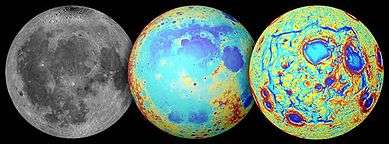
The 20th century witnessed more advances in selenography. In 1959, the Soviet spacecraft Luna 3 transmitted the first photographs of the far side of the Moon, giving the first view of it in history. The United States of America launched the Ranger spacecraft between 1961 and 1965 to photograph the lunar surface until the instant they impacted it, the Lunar Orbiters between 1966 and 1967 to photograph the Moon from orbit, and the Surveyors between 1966 and 1968 to photograph and softly land on the lunar surface. The Soviet Lunokhods 1 (1970) and 2 (1973) traversed almost 50 km of the lunar surface, making detailed photographs of the lunar surface. The Clementine spacecraft obtained the first nearly global cartograph (map) of the lunar topography, and also multispectral images. Successive missions transmitted photographs of increasing resolution.
Lunar cartography and toponymy

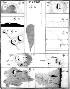
The oldest known illustration of the Moon was found in a passage grave in Knowth, County Meath, Ireland. The tomb was carbon dated to 3330–2790 BC.[2] Leonardo da Vinci made and annotated some sketches of the Moon in circa 1500. William Gilbert made a drawing of the Moon in which he denominated a dozen surface features in the late 16th century; it was published posthumously In De Mondo Nostro Sublunari Philosophia Nova. After the invention of the telescope, Thomas Harriot (1609), Galileo Galilei (1609), and Charles Scheiner (1614) made drawings also.[3]
The first serious denominations of the surface features of the Moon, based on telescopic observation, were made by Michel Florent van Langren in 1645. His work is considered the first true cartograph (map) of the Moon because it demarcated the various lunar maria, craters, and mountains and ranges. Many of his denominations were distinctly Catholic, denominating craters in honor of Catholic royalty and capes and promontories in honor of Catholic saints. The lunar maria were denominated in Latin for terrestrial seas and oceans. Minor craters were denominated in honor of astronomers, mathematicians, and other famous scholars.
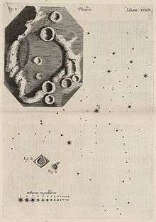
In 1647, Johannes Hevelius produced the rival work Selenographia, which was the first lunar atlas. Hevelius ignored the nomenclature of Van Langren and instead denominated the lunar topography according to terrestrial features, such that the names of lunar features corresponded to the toponyms of their geographical terrestrial counterparts, especially as the latter were denominated by the ancient Roman and Greek civilizations. This work of Hevelius influenced his contemporary European astronomers, and the Selenographia was the standard reference on selenography for over a century.
Giambattista Riccioli, SJ, a Catholic priest and scholar who lived in northern Italy authored the present scheme of Latin lunar nomenclature. His Almagestum Novum was published in 1651 as a defense of the Catholic views of the Counter Reformation. In particular he argued against the views espoused by Galileo and Copernicus of a heliocentric universe with perfectly circular orbits. Almagestum Novum contained scientific reference matter based on contemporary knowledge, and contemporary Jesuit educators widely used it. However, the only significant component of the work that is presently authoritative is his system of lunar nomenclature.
The lunar illustrations in the Almagestum Novum were drawn by a fellow Jesuit educator named Francesco Grimaldi, SJ. The nomenclature was based on a subdivision of the visible lunar surface into octants that were numbered in Roman style from I to VIII. Octant I referenced the northwest section and subsequent octants proceeded clockwise in alignment with compass directions. Thus Octant VI was to the south and included Clavius and Tycho Craters.
The Latin nomenclature had 2 components: the first denominated the broad features of terrae (lands) and maria (seas) and the second denominated the craters. Riccioli authored lunar toponyms derived from the names of various conditions, including climactic ones, whose causes were historically attributed to the Moon. Thus there were the seas of crises ("Mare Crisium"), serenity ("Mare Serenitatis"), and fertility ("Mare Fecunditatis"). There were also the seas of rain ("Mare Imbrium"), clouds ("Mare Nubium"), and cold ("Mare Frigoris"). The topographical features between the maria were comparably denominated, but were opposite the toponyms of the maria. Thus there were the lands of sterility ("Terra Sterilitatis"), heat ("Terra Caloris"), and life ("Terra Vitae"). However, these names for the highland regions were supplanted on later cartographs (maps). See List of features on the Moon#Terra for a complete list.
Many of the craters were denominated topically pursuant to the octant in which they were located. Craters in Octants I, II, and III were primarily denominated based on names from ancient Greece, such as Plato, Atlas, and Archimedes. Toward the middle in Octants IV, V, and VI craters were denominated based on names from the ancient Roman Empire, such as Julius Caesar, Tacitus, and Taruntius. Toward the southern half of the lunar cartograph (map) craters were denominated in honor of scholars, writers, and philosophers of medieval Europe and Arabic regions. The outer extremes of Octants V, VI, and VII, and all of Octant VIII were denominated in honor of contemporaries of Giambattista Riccioli. Features of Octant VIII were also denominated in honor of Copernicus, Kepler, and Galileo. These persons were "banished" to it far from the "ancients", as a gesture to the Catholic Church. Many craters around the Mare Nectaris were denominated in honor of Catholic saints pursuant to the nomenclature of Van Langren. All of them were, however, connected in some mode with astronomy. Later cartographs (maps) removed the "St." from their toponyms.
The lunar nomenclature of Giambattista Riccioli was widely used after the publication of his Almagestum Novum, and many of its toponyms are presently used. The system was scientifically inclusive and was considered eloquent and poetic in style, and therefore it appealed widely to his contemporaries. It was also readily extensible with new toponyms for additional features. Thus it replaced the nomenclature of Van Langren and Hevelius.
Later astronomers and lunar cartographers augmented the nomenclature with additional toponyms. The most notable among these contributors was Johann H. Schröter, who published a very detailed cartograph (map) of the Moon in 1791 titled the Selenotopografisches Fragmenten. Schröter's adoption of Riccioli's nomenclature perpetuated it as the universally standard lunar nomenclature. A vote of the International Astronomical Union (IAU) in 1935 established the lunar nomenclature of Riccioli, which included 600 lunar toponyms, as universally official and doctrinal.
The IAU later expanded and updated the lunar nomenclature in the 1960s, but new toponyms were limited to toponyms honoring deceased scientists. After Soviet spacecraft photographed the far side of the Moon, many of the newly discovered features were denominated in honor of Soviet scientists and engineers. The IAU assigned all subsequent new lunar toponyms. Some craters were denominated in honor of space explorers.
Satellite craters
Johann H. Mädler authored the nomenclature for satellite craters. The subsidiary craters surrounding a major crater were identified by a letter. These subsidiary craters were usually smaller than the crater with which they were associated, with some exceptions. The craters could be assigned letters "A" through "Z", with "I" omitted. Because the great majority of the toponyms of craters were masculine, the major craters were generically denominated "patronymic" craters.
The assignment of the letters to satellite craters was originally somewhat haphazard. Letters were typically assigned to craters in by order of significance rather than location. Precedence depended on the angle of illumination from the Sun at the time of the telescopic observation, which could change during the lunar day. In many cases the assignments were seemingly random. In a number of cases the satellite crater was located closer to a major crater with which it was not associated. To identify the patronymic crater, Mädler placed the identifying letter to the side of the midpoint of the feature that was closest to the associated major crater. This also had the advantage of permitting omission of the toponyms of the major craters from the cartographs (maps) when their subsidiary features were labelled.
Over time, lunar observers assigned many of the satellite craters an eponym. The International Astronomical Union (IAU) assumed authority to denominate lunar features in 1919. The commission for denominating these features formally adopted the convention of using capital Roman letters to identify craters and valleys.
When suitable cartographs (maps) of the far side of the Moon became available by 1966, Ewen A. Whitaker denominated satellite features based on the angle of their location relative to the major crater with which they were associated. A satellite crater located due north of the major crater was identified as "Z". The full 360° circle around the major crater was then subdivided evenly into 24 parts, like a 24-hour clock. Each "hour" angle, running clockwise, was assigned a letter, beginning with "A" at 1 o'clock. The letters "I" and "O" were omitted, resulting in only 24 letters. Thus a crater due south of its major crater was identified as "M".
Historical lunar maps

The following is a list of historically-notable lunar maps and atlases, arranged in chronological order by publication date.
- Michel van Langren, engraved map, 1645.
- Johannes Hevelius, Selenographia, 1647.
- Giovanni Riccioli and Francesco Grimaldi, Almagestum novum, 1651.
- Giovanni Domenico Cassini, engraved map, 1679 (reprinted in 1787).
- Tobias Mayer, engraved map, 1749, published in 1775.
- Johann Hieronymus Schröter, Selenotopografisches Fragmenten, 1st volume 1791, 2nd volume 1802.
- John Russell, engraved images, 1805.
- Wilhelm Lohrmann, Topographie der sichtbaren Mondoberflaeche, Leipzig, 1824.
- Wilhelm Beer and Johann Heinrich Mädler, Mappa Selenographica totam Lunae hemisphaeram visibilem complectens, Berlin, 1834-36.
- Edmund Neison, The Moon, London, 1876.
- Julius Schmidt, Charte der Gebirge des Mondes, Berlin, 1878.
- Thomas Gwyn Elger, The Moon, London, 1895.
- Johann Krieger, Mond-Atlas, 1898. Two additional volumes were published posthumously in 1912 by the Vienna Academy of Sciences.
- Walter Goodacre, Map of the Moon, London, 1910.
- Mary A. Blagg and Karl Müller, Named Lunar Formations, 2 volumes, London, 1935.
- Philipp Fauth, Unser Mond, Bremen, 1936.
- Hugh P. Wilkins, 300-inch Moon map, 1951.
- Gerard Kuiper et al., Photographic Lunar Atlas, Chicago, 1960.
- Ewen A. Whitaker et al., Rectified Lunar Atlas, Tucson, 1963.
- Hermann Fauth and Philipp Fauth (posthumously), Mondatlas, 1964.
- Gerard Kuiper et al., System of Lunar Craters, 1966.
- Yu I. Efremov et al., Atlas Obratnoi Storony Luny, Moscow, 1967–1975.
- NASA, Lunar Topographic Orthophotomaps, 1978.
- Antonín Rükl, Atlas of the Moon, 2004.
See also
Notes
- ↑ Wax and the Honey Moon Archived 2007-07-24 at the Wayback Machine.; an account of Maedler's work and the creation of the first wax model of the Moon.
- ↑ Stooke, Philip J. (February 1994). "Neolithic Lunar Maps at Knowth and Baltinglass, Ireland". Bibcode:1994JHA....25...39S.
- ↑ Taton, Reni (2003). Reni Taton; Curtis Wilson; Michael Hoskin, eds. Planetary Astronomy from the Renaissance to the Rise of Astrophysics, Part A, Tycho Brahe to Newton. General History of Astronomy. 2. Cambridge University Press. pp. 119–126. ISBN 0-521-54205-7.
References
- Scott L. Montgomery (1999). The Moon and Western Imagination. University of Arizona Press. ISBN 0-8165-1711-8.
- Ewen A. Whitaker (1999). Mapping and Naming the Moon: A History of Lunar Cartography and Nomenclature. Cambridge University Press. ISBN 0-521-62248-4.
- William P. Sheehan; Thomas A. Dobbins (2001). Epic Moon: A history of lunar exploration in the age of the telescope. Willmann-Bell.
External links
| Look up selenography in Wiktionary, the free dictionary. |
- NASA Catalogue of Lunar Nomenclature (1982), Leif E. Andersson and Ewen A. Whitaker
- The Galileo Project: The Moon
- Observing the Moon: The Modern Astronomer's Guide
- Lunar control networks (USGS)
- The Rise And Fall of Lunar Observing, Kevin S. Jung
- Consolidated Lunar Atlas
The Moon | ||
|---|---|---|
| Physical properties | 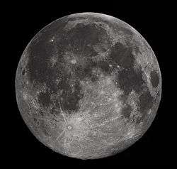 | |
| Orbit | ||
| Surface and features | ||
| Science | ||
| Exploration | ||
| Time-telling and navigation | ||
| Phases and names | ||
| Related topics | ||
| ||