Schwienau (river)
| Schwienau | |
|---|---|
 | |
| State | Lower Saxony, Germany |
| Physical characteristics | |
| Main source |
In the Lüneburg Heath near Wriedel 73 m above sea level (NN) 53°01′14″N 10°16′59″E / 53.02056°N 10.2829861°ECoordinates: 53°01′14″N 10°16′59″E / 53.02056°N 10.2829861°E |
| River mouth |
near Groß Süstedt into the Gerdau 48 m above sea level (NN) 52°58′17″N 10°23′23″E / 52.97139°N 10.389861°E |
| Length | 19.2 km (11.9 mi) [1] |
| Basin features | |
| Progression | Gerdau→ Ilmenau→ Elbe→ North Sea |
| Landmarks | Villages: Brockhöfe, Bode, Hanstedt I, Ebstorf, Wittenwater, Stadorf, Linden, Groß Süstedt |
| Tributaries |
|
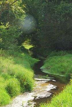
The Schwienau is a left tributary of the Gerdau in North Germany and is 19 km long. It rises in the Weidebruch north of Brockhöfe near Wriedel and discharges north of Groß Süstedt into the Gerdau. Initially it flows through near-natural grassland landscape. But after just 2.5 kilometres it has been straightened and directed past a pumping station. It has been artificially straightened throughout much of its route and rarely flows in its natural channel. The banks either side are mainly used for agriculture. Only near Wriedel and east of the village does it run through small woods and untended heath. Its fluvial sediment consists mainly of sand and mud. This affords a habitat particularly for leeches, snails and shrimp-like animals called scuds. Its water is generally only moderately contaminated.
Tributaries
|
|
References