Schefferville Airport
| Schefferville Airport | |||||||||||
|---|---|---|---|---|---|---|---|---|---|---|---|
 | |||||||||||
| Summary | |||||||||||
| Airport type | Public | ||||||||||
| Operator | Société aéroportuaire de Schefferville | ||||||||||
| Location | Schefferville, Quebec | ||||||||||
| Time zone | EST (UTC−05:00) | ||||||||||
| • Summer (DST) | EDT (UTC−04:00) | ||||||||||
| Elevation AMSL | 1,709 ft / 521 m | ||||||||||
| Coordinates | 54°48′19″N 066°48′19″W / 54.80528°N 66.80528°WCoordinates: 54°48′19″N 066°48′19″W / 54.80528°N 66.80528°W | ||||||||||
| Map | |||||||||||
 CYKL Location in Quebec | |||||||||||
| Runways | |||||||||||
| |||||||||||
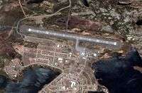
Schefferville Airport, (IATA: YKL, ICAO: CYKL), is located adjacent to the community of Schefferville, Quebec, Canada.
Airlines and destinations
| Airlines | Destinations |
|---|---|
| Air Inuit | Kangiqsujuaq, Kangirsuk, Kuujjuaq, Montréal–Trudeau, Quaqtaq, Quebec City, Salluit, Sept-Îles, Wabush |
| PAL Airlines | Wabush |
See also
References
- ↑ Canada Flight Supplement. Effective 0901Z 19 July 2018 to 0901Z 13 September 2018.
- ↑ Synoptic/Metstat Station Information
External links
- Past three hours METARs, SPECI and current TAFs for Schefferville Airport from Nav Canada as available.
| By name | |
|---|---|
| By location indicator | |
| By province/territory | |
| By area | |
| National Airports System | |
| Related | |
| |
This article is issued from
Wikipedia.
The text is licensed under Creative Commons - Attribution - Sharealike.
Additional terms may apply for the media files.