Scarpe (river)
| Scarpe | |
|---|---|
 The Scarpe at Douai | |
| Country | France |
| Physical characteristics | |
| Main source |
Pas-de-Calais 101 m (331 ft) |
| River mouth |
Scheldt 50°29′59″N 3°26′49″E / 50.49972°N 3.44694°ECoordinates: 50°29′59″N 3°26′49″E / 50.49972°N 3.44694°E |
| Length | 102 km (63 mi) |
| Basin features | |
| Progression | Scheldt→ North Sea |
| Basin size | 1,322 km2 (510 sq mi) |
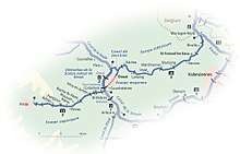
The Scarpe is a river in the Hauts-de-France region of France. It is a left-bank tributary of the river Escaut (Scheldt). It is approximately 100 kilometres (62 mi) long. The source of the river is at Berles-Monchel near Aubigny-en-Artois. It flows through the towns of Arras, Douai and Saint-Amand-les-Eaux. The river ends at Mortagne-du-Nord where it flows into the Scheldt. Scarpe Mountain in Alberta, Canada, was named after the river. The navigable waterway and its coal barges also feature in the novels by 19th century author Émile Zola.
Navigation
The river was made navigable by weirs and locks over about two thirds of its length (66 kilometres, 41 mi), divided into the Upper Scarpe (Scarpe supérieure, 23 km, 9 locks) from Arras to Courchelettes,[1] the Middle Scarpe through Douai, and the Lower Scarpe (Scarpe inférieure, 36 km, 6 locks) from Douai to the Escaut.[2][3] The Middle Scarpe is no longer navigable, bypassed by the high-capacity Canal Dunkerque-Escaut.
History
This river was navigated from the Escaut up to Douai as early as 638, but improvements with flash locks were required to give access to the important town of Arras, reached in 1613. This remained a shallow navigation, with locks of varying width and length, until it was improved to the Becquey gauge in the 1840s. The enlargement to Freycinet dimensions was completed by about 1890. Today the Lower Scarpe is closed from the Douai junction to Saint-Amand-les-Eaux pending dredging and identification of a new owner and operator.
The river and its valley were important battlegrounds in the First World War.
References
- ↑ Fluviacarte, Scarpe supérieure
- ↑ Fluviacarte, Scarpe inférieure
- ↑ Edwards-May, David (2010). Inland Waterways of France. St Ives, Cambs., UK: Imray. pp. 263–266. ISBN 978-1-846230-14-1.
External links
- River Scarpe with further maps and details of places and moorings, by the author of Inland Waterways of France
- Navigation details for 80 French rivers and canals (French waterways website section)
- The Scarpe in the Sandre database (in French) for basic catchment area data, land use and topology
| Wikimedia Commons has media related to Scarpe. |