Savica (waterfall)

Savica Falls is a waterfall in northwestern Slovenia. It is 78 m high and is fed by a karst spring also called Savica just above the waterfall.[1][2][3][4]
A large portion of water is sourced from a karst basin around Black Lake, which lies around 500 m higher above the waterfall, because of which the spring has a relatively steady and strong flow. Water flows to the spring below the ground, where it splits into two parts. After heavy rains it can happen that the water supply from the lake and its surroundings exceeds the capacity of underground tunnels, and a portion of water flows on the surface in 600 m high cascading waterfalls.
The waterfall continues in a stream of the same name, which flows into Lake Bohinj as its main source.[5] Water from Lake Bohinj is further a source of the Sava Bohinjka, which forms the Sava River after joining with the Sava Dolinka.[6]
Access
The waterfall is usually accessed from the Savica lodge, accessible from the western part of Lake Bohinj. The waterfall is about a 15-minute walk from the lodge. Is necessary to pay an entrance fee.
Gallery
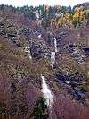 600 m high waterfall cascade that appears after heavy rains
External links

References
- ↑
Martina Zupan (1996). "Savica". Enciklopedija Slovenije. Mladinska knjiga. pp. 325–327. ISBN 86-11-14792-8. Missing or empty
|url=(help) COBISS 17411 ISBN 86-11-14288-8 OCLC 36885531 - ↑ Justi Carey, Roy Clark (May 11, 2015). "Walk 22 (Savica waterfall)". The Julian Alps of Slovenia: Mountain Walks and Short Treks. Cicerone Press Limited. ISBN 978 1 85284 7098. Archived from the original on 2017-07-22. Retrieved 2017-07-05.
- ↑ Rough Guides (Jun 1, 2017). The Rough Guide to Slovenia. Rough Guides UK. p. 124. Archived from the original on 2017-07-22. Retrieved 2017-07-05.
- ↑ James Stewart (2006). Slovenia. Cadogan Guides. New Holland Publishers. p. 98. Archived from the original on 2017-07-22. Retrieved 2017-07-05.
- ↑ Mihael BrenčičEmail, Polona Vreča (April 2016). "Hydrogeological and isotope mapping of the karstic river Savica in NW Slovenia". Environmental Earth Sciences, 75: 651. Springer. Retrieved 2017-07-05.
- ↑ Baedeker, Karl (1879) "Terglou: The Valley of the Wocheiner Save" The Eastern Alps: Including the Bavarian Highlands, the Tyrol, Salzkammergut, Styria, and Carinthia (4th ed.) Dulau and Co., London, p. 353, OCLC 4018143
Coordinates: 46°17′34″N 13°47′47″E / 46.2927785°N 13.7964048°E