Savant Lake (Sturgeon Lake) Water Aerodrome
| Savant Lake (Sturgeon Lake) Water Aerodrome | |||||||||||
|---|---|---|---|---|---|---|---|---|---|---|---|
| Summary | |||||||||||
| Airport type | Public | ||||||||||
| Operator | Rusty Myers Flying Service Ltd. | ||||||||||
| Location | Savant Lake, Ontario | ||||||||||
| Time zone | CST (UTC−06:00) | ||||||||||
| • Summer (DST) | CDT (UTC−05:00) | ||||||||||
| Elevation AMSL | 1,342 ft / 409 m | ||||||||||
| Coordinates | 50°11′15″N 090°41′33″W / 50.18750°N 90.69250°WCoordinates: 50°11′15″N 090°41′33″W / 50.18750°N 90.69250°W | ||||||||||
| Map | |||||||||||
 CJP3 Location in Ontario | |||||||||||
| Runways | |||||||||||
| |||||||||||
|
Source: Water Aerodrome Supplement[1] | |||||||||||
Savant Lake (Sturgeon Lake) Water Aerodrome, (TC LID: CJP3), is located 3.5 nautical miles (6.5 km; 4.0 mi) southeast of Savant Lake, Thunder Bay District, Ontario, Canada.
Located 0.81 NM (1.50 km; 0.93 mi) north-east at 50°11′40″N 90°39′50″W / 50.19444°N 90.66389°W is the abandoned "Savant Lake Aerodrome" at an elevation of 453 m (1,486 ft). The gravel strip is visible from the air and is still listed on the visual flight rules (VFR) aeronautical charts.
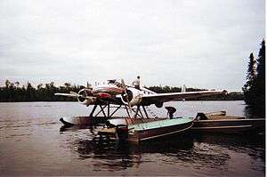
Beech Model 18 in Ontario Canada (2005?)
References
- ↑ Nav Canada's Water Aerodrome Supplement. Effective 0901Z 7 March 2013 to 0901Z 3 April 2014
| By name | |
|---|---|
| By location indicator | |
| By province/territory | |
| By area | |
| National Airports System | |
| Related | |
| |
This article is issued from
Wikipedia.
The text is licensed under Creative Commons - Attribution - Sharealike.
Additional terms may apply for the media files.