Savana Island, U.S. Virgin Islands
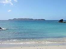 Savana Island, as seen from the west end of St. Thomas | |
 U:S: Virgin Islands | |
| Location |
Savana Island United States Virgin Islands |
|---|---|
| Coordinates | 18°20′15.0″N 65°04′59.5″W / 18.337500°N 65.083194°W |
| Markings / pattern | white tower |
| Focal height | 91 metres (299 ft) |
| Light source | solar power |
| Range | 7 nautical miles (13 km; 8.1 mi) |
| Characteristic | Fl W 4s. |
| Admiralty number | J5610 |
| NGA number | 14604 |
| USCG number | 3-31690[1][2] |
Savana Island is an islet of the United States Virgin Islands. It is located off the West End of St. Thomas at 18°20'N 65°05'W, approximately 7 miles west of Cyril E. King Airport. (See also Minor islands of the United States Virgin Islands).
See also
References
- ↑ U.S. Virgin Island The Lighthouse Directory. University of North Carolina at Chapel Hill. Retrieved 11 January 2017
- ↑ List of Lights, Pub. 110: Greenland, The East Coasts of North and South America (Excluding Continental U.S.A. Except the East Coast of Florida) and the West Indies (PDF). List of Lights. United States National Geospatial-Intelligence Agency. 2016.
Charlotte Amalie (capital) | |
| Topics |
|
| Government | |
| Cities | |
| Islands | |
| Parks | |
Coordinates: 18°20′22″N 65°04′45″W / 18.33944°N 65.07917°W
This article is issued from
Wikipedia.
The text is licensed under Creative Commons - Attribution - Sharealike.
Additional terms may apply for the media files.