Saunders, Stanton County, Kansas
| Saunders, Kansas | |
|---|---|
| Unincorporated community | |
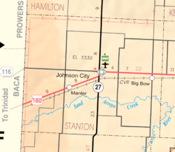 KDOT map of Stanton County (legend) | |
 Saunders  Saunders | |
| Coordinates: 37°28′16″N 102°2′22″W / 37.47111°N 102.03944°WCoordinates: 37°28′16″N 102°2′22″W / 37.47111°N 102.03944°W | |
| Country | United States |
| State | Kansas |
| County | Stanton |
| Elevation | 3,661 ft (1,116 m) |
| Time zone | UTC-6 (CST) |
| • Summer (DST) | UTC-5 (CDT) |
| Area code | 620 |
| FIPS code | 20-63175 |
| GNIS ID | 484533 [1] |
Saunders is an unincorporated community in Stanton County, Kansas, United States.[1][2]
References
Further reading
External links
Municipalities and communities of Stanton County, Kansas, United States | ||
|---|---|---|
| Cities |  | |
| Unincorporated communitis | ||
This article is issued from
Wikipedia.
The text is licensed under Creative Commons - Attribution - Sharealike.
Additional terms may apply for the media files.