Sarantaporos (Epirus)
| Sarantaporos | |
|---|---|
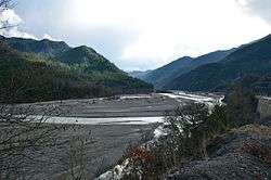 Sarantaporos near Pyrsogianni | |
| Country | Albania, Greece |
| Physical characteristics | |
| Main source | Pindus, Greece |
| River mouth |
Aoös 40°4′18″N 20°35′17″E / 40.07167°N 20.58806°ECoordinates: 40°4′18″N 20°35′17″E / 40.07167°N 20.58806°E |
| Length | 50 km (31 mi) |
| Discharge |
|
| Basin features | |
| Progression | Vjosë→ Adriatic Sea |
| Basin size | 870 km2 (340 sq mi) |
The Sarantaporos (Greek: Σαραντάπορος) is a river in northwestern Greece and southern Albania. It is a right tributary of the river Aoös (Vjosë), which flows into the Adriatic Sea. Its length is 50 km (31 mi), of which the final approx. 10 km (6.2 mi) form the border between Greece and Albania. Its source is between the mountain ranges Gramos and Voio, in the Kastoria regional unit. It flows through the municipal units Arrenes, Mastorochoria and Konitsa in Greece, and the municipalities Qendër Leskovik and Çarshovë in Albania. Its basin area is 870 km2 (340 sq mi), and its year-average discharge is 6.93 m3 (245 cu ft) per second.[1]
See also
References
- ↑ Ministry of Agriculture Archived 2007-10-27 at the Wayback Machine.
This article is issued from
Wikipedia.
The text is licensed under Creative Commons - Attribution - Sharealike.
Additional terms may apply for the media files.