Saraavesi
| Saraavesi | |
|---|---|
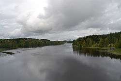 Saraavesi as seen from Liisanniemi bridge | |
| Coordinates | 62°25′N 025°59′E / 62.417°N 25.983°ECoordinates: 62°25′N 025°59′E / 62.417°N 25.983°E |
| Primary inflows | Kuusaankoski, Tarvaalanvirta |
| Primary outflows | Kuhankoski |
| Catchment area | Kymijoki |
| Basin countries | Finland |
| Surface area | 10.488 km2 (4.049 sq mi) |
| Average depth | 5.79 m (19.0 ft) |
| Max. depth | 39.85 m (130.7 ft) |
| Water volume | 0.061 km3 (49,000 acre⋅ft) |
| Shore length1 | 62.5 km (38.8 mi) |
| Surface elevation | 84.7 m (278 ft) |
| Frozen | December–April |
| Settlements | Laukaa |
| References | [1] |
| 1 Shore length is not a well-defined measure. | |
Saraavesi is a medium-sized lake in Laukaa, Finland. It flows to lake Leppävesi via Kuhankoski rapids. The lake is part of Keitele Canal, a waterway connecting Lake Keitele and Päijänne.[2] Saraakallio rock paintings are located on the shore of Saraavesi.[3]
Several parts of the lake are included to the Natura 2000 protection program. There are a shallow lake Peukaloinen, Saraakallio rocks, eskers, Tarvaalanvirta and Kuusaankoski rapids and some cultural heritage places.[4]
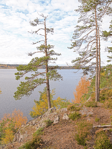
Saraakallio rocks and Saraavesi lake
See also
References
- ↑ "Saraavesi (14.321.1.001)". Järviwiki. Finnish Environment Institute. Retrieved 24 August 2012. (in English)
- ↑ Via Keitele Canal from Lake Päijänne to Lake Keitele. Retrieved 2014-02-19.
- ↑ Visiting Saraakallio rock paintings. Jyväskylä University. Retrieved 2014-02-19.(in English)
- ↑ Vatianjärven-Saraaveden suojelualue. Environment Authortity of Finland. Retrieved 2014-02-20. (in Finnish)
External links

This article is issued from
Wikipedia.
The text is licensed under Creative Commons - Attribution - Sharealike.
Additional terms may apply for the media files.