Sanuki-Saida Station
Sanuki-Saida Station 讃岐財田駅 | |
|---|---|
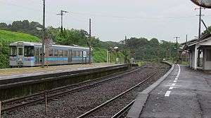 The platforms of Sanuki-Saida Station in 2013. Note the pedestrian level crossing to the island platform. | |
| Location |
Saitacho Saitakami, Mitoyo, Kagawa Prefecture, 769-0401 Japan |
| Coordinates | 34°07′02″N 133°48′54″E / 34.1172°N 133.8150°ECoordinates: 34°07′02″N 133°48′54″E / 34.1172°N 133.8150°E |
| Operated by |
|
| Line(s) | ■ Dosan Line |
| Distance | 23.9 km from Tadotsu |
| Platforms | 1 island platform, 1 side platform |
| Tracks | 3 |
| Construction | |
| Parking | Available |
| Disabled access | Yes - platforms are linked by ramps and a pedestrian level crossing |
| Other information | |
| Status | Unstaffed |
| Station code | D18 |
| History | |
| Opened | 21 May 1923 |
| Location | |
 Sanuki-Saida Station Location within Japan | |
Sanuki-Saida Station (讃岐財田駅 Sanuki-Saida-eki) is a railway station on the Dosan Line in Mitoyo, Kagawa Prefecture, Japan. It is operated by JR Shikoku and has the station number "D18".[1][2]
Lines
The station is served by JR Shikoku's Dosan Line and is located 23.9 km from the beginning of the line at Tadotsu.[3][4]
Layout
The station, which is unstaffed, consists of a side platform and an island platform serving three tracks. A building adjacent to the side platform serves as a passenger waiting room. A pedestrian level crossing spanning two tracks gives access to the island platform. Parking and a bike shed are available.[1][5]
 Front entrance of the station building. The large tree in the foreground is an 800-year old tabunoki tree.
Adjacent stations
| « | Service | » | ||
|---|---|---|---|---|
| Dosan Line | ||||
| Kurokawa | - | Tsubojiri | ||
History
The station opened on 21 May 1923 when the then Sanuki Line (讃岐線), operated by Japanese Government Railways (later becoming Japanese National Railways (JNR) was extended from Kotohira to Sanuki-Saida. With the privatization of JNR on 1 April 1987, control of the station passed to JR Shikoku.[4][6]
Surrounding area
See also
References
| Wikimedia Commons has media related to Sanuki-Saida Station. |
- 1 2 "土讃線 多度津-阿波池田間 その6" [Dosan Line Tadotsu - Awa-Ikeda Part 6]. kukanzeneki.net. Retrieved 13 December 2017.
- ↑ "Shikoku Railway Route Map" (PDF). JR Shikoku. Retrieved 25 November 2017.
- ↑ "Sanuki-Saida Station Timetable" (PDF). JR Shikoku. Retrieved 13 December 2017.
- 1 2 Ishino, Tetsu et al. (eds.) (1998). 停車場変遷大事典 国鉄・JR編 [Station Transition Directory - JNR/JR] (in Japanese). II. Tokyo: JTB Corporation. p. 664. ISBN 4533029809.
- ↑ "讃岐財田" [Sanuki-Saida]. hacchi-no-he.net. Retrieved 13 December 2017.
- ↑ Ishino, Tetsu et al. (eds.) (1998). 停車場変遷大事典 国鉄・JR編 [Station Transition Directory - JNR/JR] (in Japanese). I. Tokyo: JTB Corporation. p. 217. ISBN 4533029809.
- ↑ "財田駅前のタブノキ" [Tabunoki tree in front of Saida Station]. www.pref.kagawa.lg.jp. Retrieved 13 December 2017.
- ↑ "厳島神社のタブ樹林(植物)" [Tabunoki forest at Itsukushima Shinto shrine (flora)]. www.pref.kagawa.lg.jp. Retrieved 13 December 2017.