Santo Tomas, Davao del Norte
| Santo Tomas | |
|---|---|
| Municipality | |
| Municipality of Santo Tomas | |
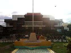 Municipal Hall | |
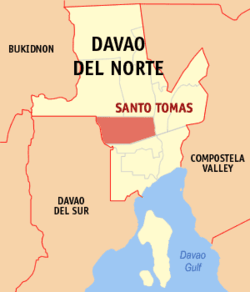 Map of Davao del Norte with Santo Tomas highlighted | |
.svg.png) Santo Tomas Location within the Philippines | |
| Coordinates: 7°32′N 125°37′E / 7.53°N 125.62°ECoordinates: 7°32′N 125°37′E / 7.53°N 125.62°E | |
| Country |
|
| Region | Davao Region (Region XI) |
| Province | Davao del Norte |
| District | 2nd District |
| Founded | August 14, 1959 |
| Barangays | 19 (see Barangays) |
| Government [1] | |
| • Type | Sangguniang Bayan |
| • Mayor | Daniel Batosalem Jr. |
| • Electorate | 57,387 voters (2016) |
| Area [2] | |
| • Total | 221.8 km2 (85.6 sq mi) |
| Population (2015 census)[3] | |
| • Total | 118,750 |
| • Density | 540/km2 (1,400/sq mi) |
| Time zone | UTC+8 (PST) |
| ZIP code | 8112 |
| PSGC | 112318000 |
| IDD : area code | +63 (0)84 |
| Climate type | Tropical rainforest climate |
| Income class | 1st municipal income class |
| Revenue (₱) | 296,102,536.71 (2016) |
| Native languages |
Davawenyo Cebuano Ata Manobo Kalagan language Tagalog |
| Website |
www |
Santo Tomas, officially the Municipality of Santo Tomas, is a 1st class municipality in the province of Davao del Norte, Philippines. According to the 2015 census, it has a population of 118,750 people.[3]
Etymology
Sto. Tomas was so named after Saint Thomas, the patron saint of Danao which is the hometown of then Governor of undivided Davao Province Vicente Duterte, father of the 16th Philippine president Rodrigo Duterte.
History
What is now Sto. Tomas, initially called Tibal-og, was once part of the jurisdiction of nearby town of Kapalong. Before the 1950s. the place used to be a lush forest inhabited by the indigenous Ata-Manobo people.
According to the town's pioneering residents, the area of what is now Kapalong (in which what is now Sto. Tomas was still part of) and Panabo City were planted for abaca during the pre-war years.
After the founding of Sto. Tomas as a municipality, it continued to grow and prosper, even as it went several successions of mayoralty governance throughout its history.
Geography
Sto. Tomas is located on the island of Mindanao, and it is in the province's second political district. It is bounded in the north by the Municipalities of Kapalong and Talaingod, in the east by the Municipality of Asuncion, in the west by Davao City, and in the south by the Municipality of Braulio E. Dujali.
Barangays
Sto. Tomas is politically subdivided into 19 barangays.
- Balagunan
- Bobongon
- Casig-Ang
- Esperanza
- Kimamon
- Kinamayan
- La Libertad
- Lungaog
- Magwawa
- New Katipunan
- New Visayas
- Pantaron
- Salvacion
- San Jose
- San Miguel
- San Vicente
- Talomo
- Tibal-og (Poblacion/Town Center)
- Tulalian
Climate
Rainfall in Sto. Tomas is evenly distributed throughout the year. Being a nearly typhoon-free municipality, the production of high value crops is favorable all year round and makes a profitable investment.
Demographics
| Population census of Sto. Tomas | ||
|---|---|---|
| Year | Pop. | ±% p.a. |
| 1960 | 16,687 | — |
| 1970 | 21,241 | +2.44% |
| 1975 | 31,584 | +8.28% |
| 1980 | 44,512 | +7.10% |
| 1990 | 67,916 | +4.32% |
| 1995 | 77,182 | +2.43% |
| 2000 | 84,367 | +1.93% |
| 2007 | 97,210 | +1.97% |
| 2010 | 109,269 | +4.35% |
| 2015 | 118,750 | +1.60% |
| Source: Philippine Statistics Authority[3][4][5][6] | ||
Sto. Tomas is home to a diverse culture inter-mingling with Mandaya and Ata-Manobo. The people are predominantly Cebuano.
Economy
Significant to the economic development of Sto. Tomas is a number of multi-national corporations and cooperatives engaged in banana based commercial production successfully operating in the municipality. Rice production also contributes to the economic development of the municipality.
Transportation
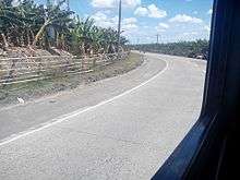
Sto. Tomas sits astride the Davao del Norte Provincial Circumferential Road. It is more or less 30 kilometres (19 mi) or about an hour ride from Tagum City by any land vehicle, and the town offers a wide choice of public utility jeepneys via Kinamayan route or bus liners via Carmen route. Davao City is approximately 63 kilometres (39 mi) or an hour and a half ride by bus or private car.
Sto. Tomas is accessible by land through any type of vehicle. There are tricycle units serving the different routes within the municipality. Most tricycles are color-coded red, with a capacity of 6 passengers per tricycle.
Education
Sto. Tomas have several public and private institutions.
Elementary schools:
- Apitong Elementary School (Public)
- Balagunan Elementary School (Public)
- Balisong Elementary School (Public)
- Bobongon Elementary School (Public)
- Casig-ang Elementary School (Public)
- Davao Winchester Colleges Inc. (Private)
- Esperanza Elementary School (Public)
- Holy Infant School of Sto. Tomas, Inc. (Private)
- Jireh School of Tomorrow (Private)
- Jesus Lumain Elementary School (Public)
- Kimamon Elementary School (Public)
- Kinamayan Integrated School (Public)
- La Libertad Elementary School (Public)
- Lunga-og Elementary School (Public)
- Magwawa Elementary School (Public)
- Marsman Elementary School (Public)
- Maryknoll High School of Santo Tomas (Private)
- Mustard Seed Christian School, Inc. (Private)
- Nafco Central Elementary School (Public)
- New Katipunan Elementary School (Public)
- New Visayas Elementary School (Public)
- Nordida SDA Elementary School, Inc. (Private)
- Pantaron Elementary School (Public)
- Philippine Baptist Christian College of Mindanao, Inc. (Private)
- Salvacion Elementary School (Public)
- San Isidro Elementary School (Public)
- San Jose Elementary School (Public)
- San Miguel Elementary School (Public)
- San Vincenzo Learning Center (Private)
- Sto. Tomas Central Elementary School - Sped Center (Public)
- Talomo Elementary School (Public)
- Talos Elementary School (Public)
- Temple Christian School, Inc. (Private)
- Tulalian Elementary School (Public)
High schools:
- Balagunan National High School (Public)
- Davao Winchester Colleges Inc. (Private)
- Kimamon National High School (Public)
- La Libertad National High School (Public)
- Marsman National High School (Public)
- Maryknoll High School of Sto. Tomas (Private)
- Mustard Seed Christian School, Inc. (Private)
- Philippine Baptist Christian College of Mindanao, Inc. (Private)
- Salvacion National High School (Public)
- Sto. Tomas National High School (Public)
- Temple Christian School Inc. (Private)
- Tulalian National High School (Public)
Tertiary education:
- Bukidnon State University (discontinued)
- Davao Winchester Colleges Inc. (Private)
- University of Southeastern Philippines
Technical/vocational schools:
- ABA Technical School of Sto. Tomas, Inc.
- Davao Winchester Colleges Inc. (Private)
Celebrations
Araw ng Sto. Tomas (lit. Day of Sto. Tomas) is a celebration held every 14th of August annually. Events include drum and lyre competitions; parades, fireworks display, and many more.
Gallery
 Row of parked tricycles outside the Sto. Tomas Central Elem. School SPED Center campus.
 Sto. Tomas Cultural Gymnasium
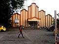 San Miguel Parish Church
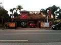 Sito's Sto. Tomas branch
References
- ↑ "Municipality". Quezon City, Philippines: Department of the Interior and Local Government. Retrieved 31 May 2013.
- ↑ "Province: Davao del Norte". PSGC Interactive. Quezon City, Philippines: Philippine Statistics Authority. Retrieved 12 November 2016.
- 1 2 3 Census of Population (2015). "Region XI (Davao Region)". Total Population by Province, City, Municipality and Barangay. PSA. Retrieved 20 June 2016.
- ↑ Census of Population and Housing (2010). "Region XI (Davao Region)". Total Population by Province, City, Municipality and Barangay. NSO. Retrieved 29 June 2016.
- ↑ Censuses of Population (1903–2007). "Region XI (Davao Region)". Table 1. Population Enumerated in Various Censuses by Province/Highly Urbanized City: 1903 to 2007. NSO.
- ↑ "Province of Davao del Norte". Municipality Population Data. Local Water Utilities Administration Research Division. Retrieved 17 December 2016.
External links
- Philippine Standard Geographic Code
- Philippine Census Information
- Local Governance
- Performance Management System
Places adjacent to Santo Tomas, Davao del Norte | ||||||||||
|---|---|---|---|---|---|---|---|---|---|---|
| ||||||||||