Santo Antão, district of Santa Maria
| District of Santo Antão Santo Antão, the 10th district of Santa Maria | |
|---|---|
| District | |
 District of Santo Antão, in Santa Maria City, Rio Grande do Sul, Brazil | |
| Coordinates: 29°37′49.20″S 53°51′37.29″W / 29.6303333°S 53.8603583°WCoordinates: 29°37′49.20″S 53°51′37.29″W / 29.6303333°S 53.8603583°W | |
| Country | Brazil |
| State | Rio Grande do Sul |
| municipality | Santa Maria |
| Government | |
| • Type | Subprefecture |
| • Body | Subprefect |
| Area | |
| • District | 51.33 km2 (19.82 sq mi) |
| Highest elevation | 450 m (1,476 ft) |
| Lowest elevation | 80 m (262 ft) |
| Population [1] | |
| • District | 807 |
| • Rank | 8th of 10 |
| • Density | 16/km2 (41/sq mi) |
| • Urban | 16 |
| • Rural | 791 |
| Neighbourhoods | 1 |
| Adjacent districts | Boca do Monte, Sede |
| Website | Official site of Santa Maria |
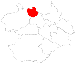
Santo Antão[2] ("Santo Antão" - Portuguese for Saint Anthony) is a district of the municipality of Santa Maria, in the Brazilian state of Rio Grande do Sul. It is situated in the north portion of Santa Maria. The district's seat is 11 km (6.84 miles) far from Downtown Santa Maria.
The district of Santo Antão owns an area of 51.33 km² that is equivalent to 8.86% of the municipality of Santa Maria that is 1791,65 km².
History
The district was created in the year of 2001 by municipal law nº 4498/01[3] with territory separated from district of Boca do Monte.
Limits
The district limits with the districts of Boca do Monte and Sede, and with the municipalities of Itaara and São Martinho da Serra
Neighbourhoods
The district of Santo Antão is divided in the following bairros, that in English is equivalent to neighbourhoods:
Roads and railway
References
- ↑ Population of the territories of Santa Maria. Brazilian Institute of Geography and Statistics in Portuguese.
- ↑ Municipal Law 0072 of 2009 that establishes the law of use and occupation of the soil, subdivision, urban perimeter and road system of the municipality of Santa Maria. - in Portuguese
- ↑ City council of Santa Maria. Municipal law 4498 de 28/12/2001.