Santo Antão, Santa Maria
| Santo Antão | |
|---|---|
| Bairro | |
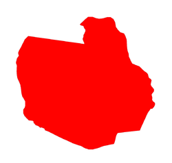 The bairro in District of Santo Antão | |
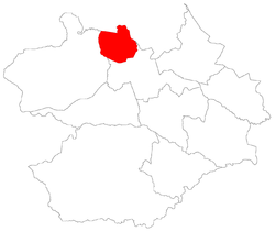 District of Santo Antão, in Santa Maria City, Rio Grande do Sul, Brazil | |
| Coordinates: 29°39′25.97″S 53°50′50.08″W / 29.6572139°S 53.8472444°WCoordinates: 29°39′25.97″S 53°50′50.08″W / 29.6572139°S 53.8472444°W | |
| Country | Brasil |
| State | Rio Grande do Sul |
| Municipality/City | Santa Maria |
| District | District of Santo Antão |
| Area | |
| • Total | 51.3300 km2 (19.8186 sq mi) |
| Population [1] | |
| • Total | 807 |
| • Density | 16/km2 (41/sq mi) |
| Adjacent bairros | Agroindustrial, Boca do Monte, Campestre do Menino Deus, Caturrita, Chácara das Flores, Nossa Senhora do Perpétuo Socorro. |
| Website | Official site of Santa Maria |
Santo Antão[2] (Portuguese pronunciation: [ˈsätu aˈtäw], "Portuguese for Saint Anthony") is a bairro in the District of Santo Antão in the municipality of Santa Maria, in the Brazilian state of Rio Grande do Sul. It is situated in north of Santa Maria.
Villages
The bairro contains the following villages: Água Negra, Campestre do Divino, Caturrita, Rondinha, Santo Antão, Vila Santo Antão.
Places adjacent to Santo Antão, Santa Maria | |
|---|---|
References
This article is issued from
Wikipedia.
The text is licensed under Creative Commons - Attribution - Sharealike.
Additional terms may apply for the media files.