Santa Rosa District, Melgar
| Santa Rosa District | |
|---|---|
| District | |
 Khunurana, Santa Rosa district | |
| Country |
|
| Region | Puno |
| Province | Melgar |
| Capital | Santa Rosa |
| Government | |
| • Mayor | Filiberto Tacca Navarro |
| Area | |
| • Total | 790.38 km2 (305.17 sq mi) |
| Elevation | 3,993 m (13,100 ft) |
| Population (2005 census) | |
| • Total | 7,454 |
| • Density | 9.4/km2 (24/sq mi) |
| Time zone | UTC-5 (PET) |
| UBIGEO | 210808 |
Santa Rosa District is one of nine districts of the province Melgar in Peru.[1]
Geography
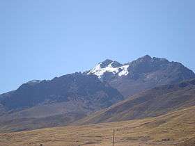
The La Raya mountain range traverses the district. Some of the highest mountains are listed below:[2]
|
Ethnic groups
The people in the district are mainly indigenous citizens of Quechua descent. Quechua is the language which the majority of the population (78.58%) learnt to speak in childhood, 21.12% of the residents started speaking using the Spanish language (2007 Peru Census).[3]
See also
References
- ↑ (in Spanish) Instituto Nacional de Estadística e Informática. Banco de Información Distrital Archived 2008-04-23 at the Wayback Machine.. Retrieved April 11, 2008.
- ↑ escale.minedu.gob.pe - UGEL map of the Melgar Province (Puno Region)
- ↑ inei.gob.pe Archived 2013-01-27 at the Wayback Machine. INEI, Peru, Censos Nacionales 2007, Frequencias: Preguntas de Población: Idioma o lengua con el que aprendió hablar (in Spanish)
| |
|---|---|
| Azángaro | |
| Carabaya | |
| Chucuito | |
| El Collao | |
| Huancané | |
| Lampa | |
| Melgar | |
| Moho | |
| Puno | |
| San Antonio de Putina | |
| San Román | |
| Sandia | |
| Yunguyo | |
This article is issued from
Wikipedia.
The text is licensed under Creative Commons - Attribution - Sharealike.
Additional terms may apply for the media files.