Cunurana (Melgar)
| Cunurana | |
|---|---|
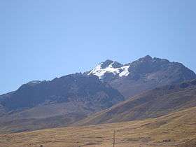 Cunurana as seen from Santa Rosa | |
| Highest point | |
| Elevation | 5,420 m (17,780 ft) [1] |
| Coordinates | 14°32′56″S 70°49′55″W / 14.54889°S 70.83194°WCoordinates: 14°32′56″S 70°49′55″W / 14.54889°S 70.83194°W |
| Geography | |
 Cunurana Peru | |
| Location | Peru, Puno Region |
| Parent range | Andes, La Raya |
Cunurana (possibly from Aymara for a variety of potato of the qhini group)[2] is a mountain in the La Raya mountain range in the Andes of Peru, about 5,420 metres (17,782 ft) high. It is situated in the Puno Region, Melgar Province, Santa Rosa District. Cunurana lies south east of La Raya mountain pass near the road and railway that connect Cusco and Juliaca.
References
- ↑ John Biggar: The Andes. A Guide for Climbers, p. 121 "Cunurana 5420m"
- ↑ "Diccionario Bilingüe, Castellano - Aymara, 2002". Félix Layme Pairumani. Retrieved January 18, 2015. (see: Variedad de papa qhini)
This article is issued from
Wikipedia.
The text is licensed under Creative Commons - Attribution - Sharealike.
Additional terms may apply for the media files.