Santa Catalina, Uruguay
| Santa Catalina | |
|---|---|
| Village | |
 Santa Catalina Location in Uruguay | |
| Coordinates: 33°47′0″S 57°29′0″W / 33.78333°S 57.48333°WCoordinates: 33°47′0″S 57°29′0″W / 33.78333°S 57.48333°W | |
| Country |
|
| Department | Soriano Department |
| Population (2011) | |
| • Total | 998 |
| Time zone | UTC -3 |
| Postal code | 75201 |
| Dial plan | +598 4538 (+4 digits) |
Santa Catalina is a village in the Soriano Department of western Uruguay.
Location
The village is located on Route 2, about 15 kilometres (9.3 mi) northwest of Cardona and 12 kilometres (7.5 mi) southeast of José Enrique Rodó. The railroad track Montevideo - Mercedes passes through the town.
History
On 19 December 1940, the status of the populated nucleus here was elevated to "Pueblo" (village) by the Act of Ley Nº 9.985.[1] Previously, it had been the head of the judicial section "Arroyo el Medio".[2]
Population
In 2011 Santa Catalina had a population of 998.[3]
| Year | Population |
|---|---|
| 1908 | 1,894 |
| 1963 | 824 |
| 1975 | 884 |
| 1985 | 882 |
| 1996 | 929 |
| 2004 | 1,053 |
| 2011 | 998 |
Source: Instituto Nacional de Estadística de Uruguay[2]
References
- ↑ "Ley Nº 9.985". República Oriental del Uruguay, Poder Legislativo. 1940. Retrieved 5 September 2012.
- 1 2 "Statistics of urban localities (1908–2004)" (PDF). INE. 2012. Retrieved 5 September 2012.
- ↑ "Censos 2011 Soriano (needs flash plugin)". INE. 2012. Retrieved 30 August 2012.
External links
Capital: Mercedes | ||
| Towns and villages | 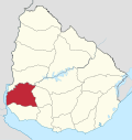 | |
| Sights | ||
This article is issued from
Wikipedia.
The text is licensed under Creative Commons - Attribution - Sharealike.
Additional terms may apply for the media files.