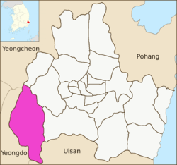
Sannae-myeon, Gyeongju
| Sannae-myeon | |
|---|---|
| Korean transcription(s) | |
| • Hangul | 산내면 Sannae-myeon |
| • Hanja | 山內面 |
| • Revised Romanization | Sannae-myeon |
| • McCune–Reischauer | Sannae-myŏn |
 | |
| Country | South Korea |
| Region | Gyeongju |
| Administrative divisions | 19 administrative ri (9 legal ri), 71 ban |
| Government | |
| • Type | Gyeongju City |
| Area | |
| • Total | 143.03 km2 (55.22 sq mi) |
| Population (2012) | |
| • Total | 3,325 |
| • Density | 23/km2 (60/sq mi) |
| Dialect | Gyeongsang dialect |
Sannae-myeon is a myeon or a township in the subdivision of Gyeongju City, North Gyeongsang province, South Korea. Its 142.64 square kilometers are home to about 3,624 people.[1] This population is served by one elementary school, two branch schools and a kindergarten affiliated with the elementary school, and one joint middle-high school.
Administrative divisions
Sannae-myeon is further divided into the following ri (administrative divisions):
- Daehyeon 1-ri (대현1리)
- Daehyeon 2-ri (대현2리)
- Daehyeon 3-ri (대현3리)
- Gamsan 1-ri (감산1리)
- Gamsan 2-ri (감산2리)
- Ilbu 1-ri (일부1리)
- Ilbu 2-ri (일부2리)
- Naechil 1-ri (내칠1리)
- Naechil 2-ri (내칠2리)
- Nae-il 1-ri (내일1리)
- Nae-il 2-ri (내일2리)
- Oechil 1-ri (외칠1리)
- Oechil 2-ri (외칠2리)
- Sin-won 1-ri (신원1리)
- Sin-won 2-ri (신원2리)
- Uigok 1-ri (의곡1리)
- Uigok 2-ri (의곡2리)
- Ura 1-ri (우라1리)
- Ura 2-ri (우라2리)
See also
References
- ↑ "산내면 Sannae-myeon 山內面" (in Korean). Doosan Encyclopedia. Archived from the original on 2013-01-02. Retrieved 2009-08-17.
External links
- The official site of the Sannae-myeon office (in Korean)
4 eup, 8 myeon, 11 dong | ||
| Eup (town) |  | |
| Myeon (township) | ||
| Dong (neighborhood) | ||
| See Also | ||
Website: www.gyeongju.go.kr | ||
This article is issued from
Wikipedia.
The text is licensed under Creative Commons - Attribution - Sharealike.
Additional terms may apply for the media files.