Sandama, Mali
| Sandama | |
|---|---|
| Village | |
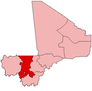
 Sandama Location within Mali | |
| Coordinates: 12°26′7″N 8°44′25″W / 12.43528°N 8.74028°WCoordinates: 12°26′7″N 8°44′25″W / 12.43528°N 8.74028°W[1] | |
| Country |
|
| Region | Koulikoro |
| Cercle | Kati Cercle |
| Commune | Sobra |
| Time zone | UTC+0 (GMT) |
Sandama is a village and seat (chef-lieu) of the rural commune of Sobra in the Kati Cercle of the Koulikoro Region of Mali.[2]
References
- ↑ Common and Fundamental Operational Datasets Registry: Mali, United Nations Office for the Coordination of Humanitarian Affairs . cheflieu_mali.zip
- ↑ Communes de la Région de Koulikoro (PDF) (in French), Ministère de l’administration territoriale et des collectivités locales, République du Mali, archived from the original (PDF) on 2012-03-09 .
This article is issued from
Wikipedia.
The text is licensed under Creative Commons - Attribution - Sharealike.
Additional terms may apply for the media files.