Sanaga River
| Sanaga River | |
|---|---|
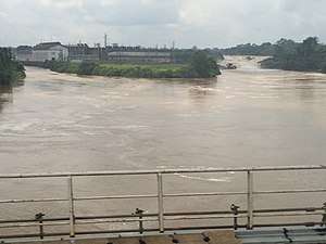 The Sanaga River after the Edea Hydroelectric Power Station | |
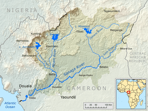 Map of the Sanaga River drainage basin | |
| Country | Cameroon |
| Regions | East Region, Centre Region, Littoral Region |
| Citys | Edéa, Nanga Eboko, Bélabo |
| Physical characteristics | |
| Main source |
Confluence of Djérem River and Lom River[1] 628 m (2,060 ft) 5°19′26″N 13°23′52″E / 5.323772°N 13.397769°E |
| River mouth |
Bight of Biafra 0 m 3°33′34″N 9°39′08″E / 3.559338°N 9.652175°E |
| Length | 582 km (362 mi), with Djérem 976 km (606 mi) |
| Discharge |
|
| Basin features | |
| River system | Sanaga River |
| Basin size | 132,990 km2 (51,348 sq mi) |
| Tributaries |
|
| Waterbodies | Song Loulou Hydroelectric Power Station, Edea Hydroelectric Power Station |
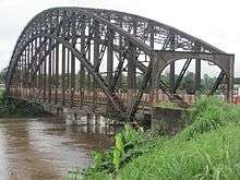
| Bridges | Japoma Bridge |
The Sanaga River (formerly German: Zannaga) is a river of East Region, Centre Region and Littoral Region of Cameroon. Its length is about 600 kilometres (370 mi).
Course
The Sanaga River has its Source at the Adamawa Plateau.[2] It is formed by the confluence of the Djérem River and Lom River in the north of the East Region. Apart from those originating rivers, its main tributary is the Mbam River.[3]
Klima
The Sanaga River forms a boundary between two tropical moist forest ecoregions. The Cross-Sanaga-Bioko coastal forests lie to the north between the Sanaga River and the Cross River of Nigeria, and the Atlantic Equatorial coastal forests extend south of the river through southwestern Cameroon and Equatorial Guinea, Gabon, the Republic of the Congo, Cabinda and the Democratic Republic of the Congo.
Hydrology
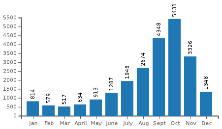
The flow of the river was measured at Edéa in m³/s[1]
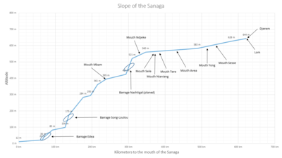
Dams and reservoirs
Beginning at the headwaters, there are 2 dams on the Sanaga River:
| Dam | Nameplate capacity (MW) | Reservoir | Surface area (km²) | Total capacity (Mio. m³) |
|---|---|---|---|---|
| Song Loulou | 384 | 10 | ||
| Edea | 264 | |||
Transport
References
- 1 2 3 PDF about the Hydrology of Cameroon (french)
- ↑ Knaap, M. van der (1994). Status of Fish Stocks and Fisheries of Thirteen Medium-sized African Reservoirs. Food & Agriculture Org. p. 11. ISBN 9789251035818.
- ↑ Runge, Jürgen (2012-05-30). Landscape Evolution, Neotectonics and Quaternary Environmental Change in Southern Cameroon: Palaeoecology of Africa Vol. 31, An International Yearbook of Landscape Evolution and Palaeoenvironments. CRC Press. p. 148. ISBN 9780415677356.
Further reading
Coordinates: 3°33′33.62″N 9°39′07.83″E / 3.5593389°N 9.6521750°E