Boumba River
| Boumba River | |
|---|---|
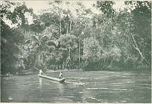 The Boumba River 1911 | |
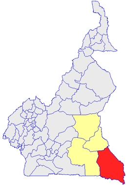 Boumba-et-Ngoko department (in red) of East Province in Cameroon (rest of map) | |
| Other name(s) | Bumba, Wumo |
| Country | Cameroon |
| Regions | East Region |
| Physical characteristics | |
| Main source |
Near Abong-Mbang 680 m (2,230 ft) 3°52′00″N 13°28′00″E / 3.86667°N 13.46667°E |
| River mouth |
Confuence with the Dja River Near Moloundou 350 m (1,150 ft) 2°02′07″N 15°11′37″E / 2.035382°N 15.193748°E |
| Length | 530 km (330 mi) |
| Discharge |
|
| Basin features | |
| River system | Kongo River |
| Basin size | 27,400 km2 (10,579 sq mi) |
| Tributaries |
|
Boumba River is a river in the South Cameroon Plateau of southeast Cameroon.
Geography
The river rises in the Abong-Mbang region. The Boumba is almost 530 km long, and has a catchment of 27.400 km² [1]
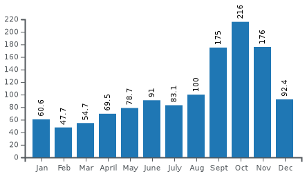
Hydrometrie
The flow of the river was measured at Biwala in m³/s[1]
Ecology
The river is a tributary of the Dja River and is adjacent to the Boumba Bek National Park, which is located between the Boumba and the Bek River. The forested area around the river is a diverse ecosystem. Logging is an industry in the area. The remote region is home to the Baka.[2] Communities in the area engage in substistence farming, hunting, fishing and gathering. The area is also used illegal commercial bushmeat hunters and traders and trophy hunters. Parrots and ivory are also smuggled through the area.[3]
Trivia
- The area is believed to be a possible origin of the HIV virus.[4]
- The legendary Mokèlé-mbèmbé was reportedly sighted on the river in 2000.