San Tomaso Agordino
| San Tomaso Agordino | |
|---|---|
| Comune | |
| Comune di San Tomaso Agordino | |
 | |
 San Tomaso Agordino Location of San Tomaso Agordino in Italy | |
| Coordinates: 46°23′N 11°59′E / 46.383°N 11.983°ECoordinates: 46°23′N 11°59′E / 46.383°N 11.983°E | |
| Country | Italy |
| Region | Veneto |
| Province | Province of Belluno (BL) |
| Frazioni | Pecol |
| Area | |
| • Total | 19.2 km2 (7.4 sq mi) |
| Population (Dec. 2004) | |
| • Total | 766 |
| • Density | 40/km2 (100/sq mi) |
| Time zone | UTC+1 (CET) |
| • Summer (DST) | UTC+2 (CEST) |
| Postal code | 32020 |
| Dialing code | 0437 |
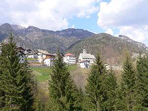
the town with the parish church
San Tomaso Agordino is a comune (municipality) in the Province of Belluno in the Italian region Veneto, located about 110 kilometres (68 mi) north of Venice and about 35 kilometres (22 mi) northwest of Belluno. As of 31 December 2004, it had a population of 766 and an area of 19.2 square kilometres (7.4 sq mi).[1]
The municipality of San Tomaso Agordino contains the frazione (subdivision) Pecol.
San Tomaso Agordino borders the following municipalities: Alleghe, Cencenighe Agordino, Rocca Pietore, Taibon Agordino, Vallada Agordina.
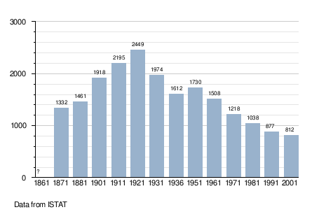
Demographic evolution
Twin towns
San Tomaso Agordino is twinned with:

References

This article is issued from
Wikipedia.
The text is licensed under Creative Commons - Attribution - Sharealike.
Additional terms may apply for the media files.