Mel, Veneto
| Mel | ||
|---|---|---|
| Comune | ||
| Comune di Mel | ||
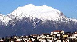 Mel and surrounding mountains | ||
| ||
 Mel Location of Mel in Italy | ||
| Coordinates: 46°4′N 12°5′E / 46.067°N 12.083°E | ||
| Country | Italy | |
| Region | Veneto | |
| Province | Belluno (BL) | |
| Frazioni | Bardies, Campo, Campo San Pietro, Carve, Carve Montagna, Col, Conzago, Cordellon, Corte, Farra, Follo, Gus, Marcador, Nave, Pagogna, Pellegai, Samprogno, San Candido, Signa, Tallandino, Tiago, Torta, Tremea, Valmaor, Vanie-Rive di Villa, Villa di Villa, Zottier | |
| Government | ||
| • Mayor | Stefano Cesa | |
| Area | ||
| • Total | 85.7 km2 (33.1 sq mi) | |
| Elevation | 362 m (1,188 ft) | |
| Population (31 December 2008)[1] | ||
| • Total | 6,272 | |
| • Density | 73/km2 (190/sq mi) | |
| Demonym(s) | Zumellesi | |
| Time zone | UTC+1 (CET) | |
| • Summer (DST) | UTC+2 (CEST) | |
| Postal code | 32026 | |
| Dialing code | 0437 | |
| Website | Official website | |


Mel is a comune (municipality) in the province of Belluno in the Italian region of Veneto, located about 170 kilometres (106 miles) north of Venice and about 14 kilometres (9 miles) southwest of Belluno and about 16 kilometres (10 miles) northeast of Feltre.
Overview
The territory of Mel is home to the medieval Zumelle Castle. The present configuration of the castle dates back to 1311, although the site was in use as a military fortification since the Roman era. Other sights include the Palazzo Zorzi (16th century, now the Town Hall) and the Palazzo delle Contesse (17th century), which houses an archaeological museum with remains from an Veneti Iron Age necropolis found outside the town.
The town is home to several cultural activities: they include art exhibitions in Palazzo delle Contesse and the choral music festival in July in the Guarnieri palace park.
References
External links
![]()
